Tuesday, April 26, 2011

Sacred Images Rock Art Exhibit

The Anasazi Heritage Center in Dolores, Colorado is hosting the Sacred Images Rock Art Exhibit from April to October 2011. Photographs of four styles of Utah Rock art are on display that may span 8000 years. The Anasazi Heritage Center acts as the Visitor Center for the Canyons of the Ancients.

The Chuska Puma greets visitors to the Anasazi Heritage Center. The Chuska Puma is part of the Pumas on Parade effort to raise awareness of mountain lions. This puma has some examples of rock art as part of its design. There are 17 or so artistic pumas on display, mostly in southwest Colorado.

The Chuska Puma was donated by the Kinder Morgan Company, who also provides road maintenance in the remote parts of the Canyons of the Ancients. My own experience is that the gas well workers have been helpful to hikers trying to find their way around the backcountry areas. The puma has been recently moved from inside the Center to this attractive outdoor position

The most ancient art is called the Barrier Canyon Style. The artists are currently called the Western Archaic Native Americans, but we are not sure who they were or even who their descendants are. They lived as hunters and gathers and left their paintings in sheltered canyons along their migration routes. The most famous place to find examples is in the Grand Gallery of Canyonlands National Park. They have many very large ghostly and spirit figures.

 The group that we used to call the Anasazi, and now call the Ancestral Pueblos were the first group to practice agriculture in Utah. The Ancestral Pueblos rock art is divided into the Basketmaker and Pueblo phases. The rock art resembles the Barrier Canyon and Fremont style but the images include arms and hands and more details.

There are some relatively easy panels to find along the San Juan River near Bluff, Utah, particularly the Sand Island boat launch site. The small panels that are visible at Mesa Verde are some Colorado examples. The Pueblo phase people produced less rock art, but more decorated pottery, weaving, and kiva painting.

The Ute Style is the most recent, dated from 1600 to 1930. The Ute Style features horses, bison, and shield-shaped stick figures. The Ute Mountain Tribal Park near Cortez, CO has some Ute local examples, and horse figures are found in a few places in the Canyons of the Ancients.

In the gallery room, the pictures are arranged around the outer wall, with a center section. Each picture has a short description, and there are interpretive posters giving general information on each style. I was hoping for maps that would show where the sites are located, but no luck.
 
The group that we call the Fremonts lived in the northern three quarters of Utah from 400 to 1300 AD. We don’t know who their ancestors or their descendants are. There are several styles of Fremont work, with many animals, hunting scenes and horned human figures.

There is a book of these same pictures on sale in the gift shop. I would like these books to include maps or directions that show how to visit these sites yourself, but they usually don’t.


Friday, April 22, 2011

Squaw Point Mesa Top

The Squaw Point Mesa Top is the area between Cross Canyon on the east and Squaw Canyon on the west, in the Canyons of the Ancients in soutwest Colorado. The access is to follow paved Road 6 south from Dove Creek, CO. The route zig zags west in several places but continues south on Roads 5 and 4. The Canyons of the Ancients area definitely begins at a cattle guard after about 17 miles.


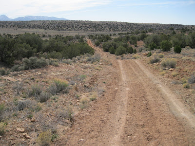
At about 19 miles, the well maintained county roads end at a drill site, but a dirt BLM road makes a right turn and is marked with a National Monument sign. The dirt road is bumpy but is drivable. It is marked as a “Designated Route” for motorized travel. I continued driving 2 more miles down this road. There are several side roads along the way, but I only saw one side road that was also a Designated Route.
 
At about 2 miles down the dirt road, there is a short turn off that provides some good views of Squaw Canyon. The area in view is in the Squaw/Papoose Canyon Wilderness Study Area. It appears to be over the state line into Utah, but still part of the BLM managed lands.
 
I was surprised to see what I think is a Navajo Hogan type structure built into the canyon rim. The doorway may be oriented south rather than the traditional east. The roof uses cribbed juniper logs, but has some plastic sheet built in.

Overlooking the Hogan to the south, there is a boulder based ruins site visible about 0.4 miles away. This site isn’t visible from the road. I drove a little further south and hiked to it, but the hiking distance is about the same whether you drive further or not.
 

The boulder is located just below a point and has a commanding view below, across, and to each side. There is a small section of still standing wall segment.
 
Most of the rubble appears to have fallen on the south side. There is an old but modern ladder among the debris. My side trip hike here took about 0:40 minutes.
 
Coincidentally, at the point where I parked about 0.4 miles south of the Navajo Hogan, there is a mesa top ruins site very close to the road. Though it is visible from the road, it is overgrown with sage brush. This mesa top site was about 100 yards from the canyon rim and about 0.4 miles from the boulder lookout ruins site.


The road continues south through a large sagebrush field. I stopped at a random point and walked about 0.3 miles to the Cross Canyon west rim. Cross Canyon continues to the McLean Basin area. In the southwest side of McLean Basin, there is a rough road that climbs up and probably connects to this mesa top road, but I didn’t get that far. I stopped at a fence and gate that was 4.2 miles past the Canyons of the Ancients sign.

Sunday, April 17, 2011

Woods Canyon Mesa Top

The Mesa Top area between the Canyons of the Ancients Woods Canyon on the east and Sandstone Canyon on the west can be accessed along County Road W west of the Community of Yellow Jacket in southwest Colorado.

The turn off is west on County Road Y from Highway 491, then south on Road 16 to Road W. At the end of Road W near a gas facility, BLM Road 4529 provides as easy trail. I followed the BLM road as it twisted south and east for about 1.5 miles until it ends with a turnaround circle.

On this hike I wanted to see where this road goes and didn’t detour off even though most of the Ancestral Pueblo ruins sites and the good views are usually found near the canyon rims. At the road end, hiking can continue for another 1.5 miles or so out toward an overlook of the junction of Woods Canyon and Sandstone Canyon.

The mesa top area has some narrow sections where there are views both east and west. The west view is one of the best available views of the middle part of Sandstone Canyon. It looks like there is a trail leading toward the canyon bottom below the view point, but I didn’t see where this trail might connect to the mesa top. I scanned the area below with binoculars and didn’t spot any ruins sites, but they are often obscured by the forest.
 

Further out toward the junction overlook on the Woods Canyon side, I spotted a small rubble pile ruins site just below the rim. It was easy to find a way down for a closer look, but this appeared to be a small site without any walls still intact.
 

On a previous hike south of the Woods Canyon Pueblo site, I sighted a square tower in the cliffs below the neck area of this mesa top. It is in an alcove in the darker rock layer that is near the canyon bottom. I looked all along the rim above this structure but couldn’t see the tower from above. I did see a couple of rock cairns in the vicinity, but these didn’t help me find a view point.
 
The cliffs are very steep here. I looked around for more than an hour but the only view of the tower I could find was to descend all the way to the canyon bottom and slightly up the other side. I came across a trail at the bottom of the canyon, probably a cow trail.
 
Besides the cliffs above the tower, there are also cliffs below and the side approaches seemed steep, so I didn’t get a better view than the one from across the canyon. From below, it looks like there should be a route to view the site closer, but the straight up approach is steep. My approach was toward the south side where it was less steep but the structure goes out of site as you climb.

My total hike took 4:30 hours for about 6 miles on a 56 F degree windy mid April day. I carried and drank 3 liters of water.


Saturday, April 2, 2011

Holly Ruins to Bridge Canyon -Bike Trail

The Holly Ruins Group is one of the outlying sites of Hovenweep National Monument in southwest Colorado. The rough road leading to the Holly and Horseshoe Units is about 5 miles north of the Hovenweep Visitor Center along County Road 10.


I started my hike close to the Holly Ruins Unit and continued south and east along the BLM road into the Canyons of the Ancients. This is part of a loop route in this area that mountain bikers follow. The Holly Group features several structures that are perched on large boulders including Tilted Tower where the boulder has shifted, dumping most of the structure into Keeley Canyon.
 

After about 10 minutes of hiking there is a marked junction with BLM Road 4723 turning south and Road 4721 continuing southeast. I stayed to the left on 4721 which crosses the canyon bottom of Bridge Canyon. Toward the east side there are two side canyons as the road begins to climb to the mesa top area between Bridge Canyon and Hovenweep Canyon. The first side canyon has two small stock ponds near the road.

The ridge between the two side canyons has a large rubble pile ruins visible from the east side as the road climbs to the mesa top area. I approached from the east side and found a way up to the site, but there is a layer of cliffs and the way wasn’t easy. This site isn’t visible from the west side near the stock ponds, though the climb up looks easier from that side.


There are collapsed structures in front of the boulder based rubble piles. I was 0:45 minutes into my hike when I spotted this site and it took a total of 1:00 hour to arrive. I had to look around for several minutes to find a way to climb up and only found one gap in the cliffs below the east side.
 

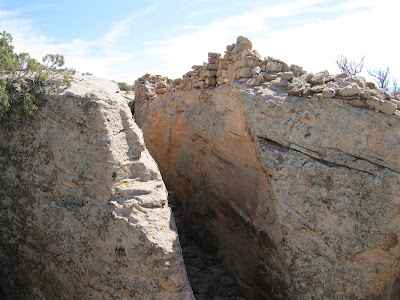
On the back side of the large boulders, there was an interesting wall section that blocked access to the site from the east. The routes up were so limited and difficult that I wondered if this was more of a safety fence than a barrier to entry.
 

The best wall sections still holding together were on the back side along the boulder top. There is just a narrow passage way along the back side between the structures and other large boulders. The style of brickwork makes an obvious change from the left to right sides. The visible pottery shards that I saw here were a mix of corrugated and painted black on white.


It was easier to descend down the west side of the ridge to the drainage and loop back to the stock ponds, than to return the way I came. From the ruins site, it only took 0:10 minutes to return to the ponds. From the ponds I retraced a short distance east and arrived at the mesa top area on the east side of Bridge Canyon. I turned around at the marked junction with BLM Road 4722 that heads north.


Road 4722 is part of the bike route and eventually loops west to a junction with County Road 10 about 1 mile north of the Holly turnoff and there is an old corral visible near the intersection. My return hike took 0:50 minutes and my total hike took 2:40 hours. I also made a short visit to the Holly Ruins Group. It was 56 F degrees at my 10:20 AM start and 68 F degrees at my 1:00 PM finish on a warmer than average early April day. I carried and drank 2 liters of water.


                                        544544_Travelation: More flights. Lowest price, guaranteed with no booking fees