Friday, December 10, 2010

Yellowjacket Canyon near Woods Canyon

Yellowjacket Canyon is one of the largest of the rugged Canyons of the Ancients in southwest Colorado. There is an access to the north rim along the extension of County Road 14, south of County Road U. This area is west of the community of Yellowjacket, northwest of Cortez, CO along highway 491.


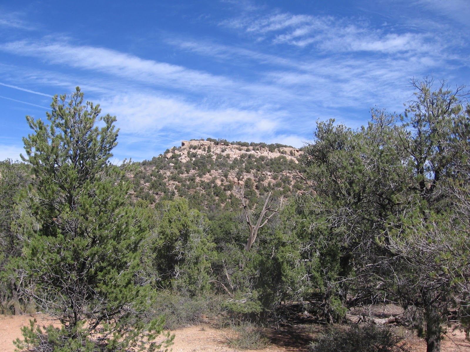
From the trailhead area near the Carbon Dioxide Gas Plant  into Woods Canyon at Roads 14 and U, I continued driving south for 2.3 miles to a point where there are views along the north rim of Yellowjacket Canyon. The well maintained gravel road continues for about one mile to several carbon dioxide gas wells. I started hiking west along the canyon rim, parallel to the road.


Yellowjacket Canyon is oriented east and west in this area and is very deep and wide with a flat canyon bottom. There is a meandering creek along the floor. In some areas the Yellowjacket Canyon floor is still private property with farming operations. I was hiking slowly, stopping frequently to scan with binoculars for Ancestral Pueblo ruins sites.
 
After about 1:00 hour, but only about 0.6 miles I came across a rubble pile site that was about 50 feet back from the rim. Many of these sites sit on the rim and spill over the edge, but this one was more of a mesa top site. I didn’t spot any ruins sites below the rim or near the canyon floor.


This site looked like it had at least two large rubble pile structures and a large circular depression and some perimeter walls. Not much has held together above ground, but it looks like a fairly large site.
                          

I continued west for about another 0.5 miles to a view point. I turned around at the view point, but there is about another mile of mesa top out to a rocky cap that overlooks the junction of Yellowjacket Canyon and the unnamed side canyon to the north. There is a rough trail  that continues along the mesa top.


On the return hike, I followed the rough trail back east to where it connects with the end of the maintained gravel road. Before that junction I found another mesa top site, somewhat smaller than the previous one. There were at least two rubble piles at this site, both overgrown with sagebrush and trees. My return hike only took about 0:30 minutes out of total hike of 2:30 hours for about 2 miles. I hiked on a mild 46 F degree early December day.


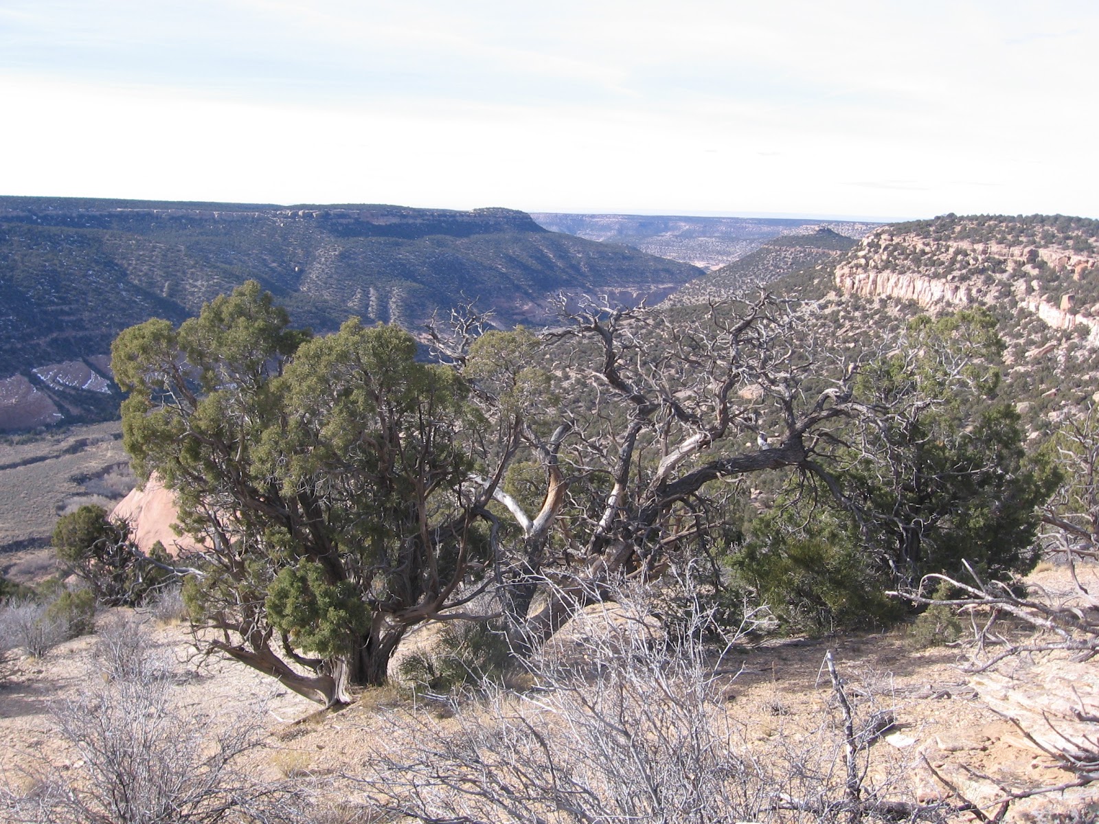
 Two days later I returned to the same area and continued on the rough  trail to the rocky cap overlooking the point where Yellowjacket Canyon makes a bend to the southwest. I started at the end of the well maintained gravel road, and re-hiked the first 0.5 miles of ATV trail, passing the second ruins site again. At the end of the point, about 1.5 miles of hiking, a little past the rocky outcrop, there are good views down Yellowjacket Canyon.


I saw one small ruins site along the south facing canyon rim a short distance before the rocky outcrop. The rocky outcrop itself appeared to have a small shelter ruin with a small wall fragment. I spent 2:20 hours on this segment of hiking of about 3 miles. (There are several other ruins sites in this area. Use the Yellow Jacket Canyon labels.)


Sunday, November 14, 2010

Little Ruin Canyon Trail in Fall

The Little Ruin Canyon Trail is located at the Visitor Center of Hovenweep National Monument along the south Utah and Colorado border. The 2 mile loop visits at least 10 Ancestral Pueblo Ruins sites, mostly perched along the canyon rims.


Little Ruins Canyon appears to be dryer and more desert like than most of the surrounding Canyons of the Ancients area. The mesa top area is mostly Sagebrush, Mormon Tea, Cliff Rose, Prickly Pear Cactus, with a few scattered Utah Juniper trees. These plants are identified with small signs on the trail segment close to the Visitor Center. The canyons only a few miles further north are much thicker Pinon Pine and Juniper forest. Most of these plants retain some green color into the fall and winter seasons.

The trail here at the Hovenweep Visitor Center provides more ruin site viewing in a short distance than most trails in the region. The nearby Sand Canyon Trail has many small sites and Chaco Canyon in northwest New Mexico has very large sites. Sun Point at Mesa Verde has many sites visible from one view point.

Following the loop trail clockwise, there is an 80 foot descent into the canyon and a climb out the other side. The canyon interior is closed except for special tours. Several of the ruins sites can be viewed from this low angle including Stronghold House, the Twin Towers and Eroded Boulder House. Climb a little higher and Point Tower, Unit Type House, and Rim Rock House are visible. The canyon bottom has thicker vegetation than the canyon rim area, with some Rabbitbrush visible. The canyon head area has some Hackberry Trees.


The upper end of the south fork of the canyon head has some of the largest and most impressive of the Hovenweep Towers. Hovenweep Castle across the canyon head is the largest and most impressive. The Square Tower down below the rim is the most mysterious and seems to have been build with slight spiral. It overlooks the spring that provided water for the overall site.
 
There are a few small structures that aren’t pointed out. From the Tower Point loop segment looking north there are some small storage structures in the shallow alcoves under the rim. In fall, these small storage areas were probably stocked with the produce of the summer season.
 

Another unnamed ruins structure is at the point where the trail begins to descend into and cross the small canyon. This unnamed site would be a major find along the wild canyons of Canyons of the Ancients but is easily ignored here. Looking east, there is a view toward Sleeping Ute Mountain. 

The Holly Trail leads from the campground 4 miles north to the Holly Ruins Group, the nearest outlying site of Hovenweep. The Little Ruins Canyon Trail takes 1 or 2 hours depending on how long you linger at each site. I hiked in mid November on a sunny 45 F degree day and there were about 10 other vehicles at the visitor center during my visit.


Friday, November 5, 2010

Woods Canyon Square Tower

There is an old road that provides an easy descent down into Woods Canyon in the Canyons of the Ancients in southwest Colorado. The access is at the corner of County Roads U and 14, west of the community of Yellowjacket, northwest of Cortez, CO along Highway 491.

There is some parking along the road across from one of the carbon dioxide plants in the area. The south leg of the trail leads to a large Ancestral Pueblo ruins site after about 0:45 minutes of hiking.


I continued on the trail past the Woods Canyon Pueblo for another 0:40 minutes until the route seemed to fizzle out in a thick sagebrush field. In the fall, the creek at the bottom of Woods Canyon had a healthy flow of water. The northwest canyon slope appeared easy to climb at this point, so I decided to walk up hill to get a better view. I didn’t realize it, but the mouth of a side canyon was only a short distance ahead.


At the hill top, I had a good view into the side canyon and noticed a square tower perched on the west side cliffs, below the rim. From the distance, I couldn’t see any other structures nearby. This location made it appear that the tower kept a watch on the side canyon entrance. The area below the tower appeared to be steep and I decided just to view the tower from the distance. I was 1:50 hours into my hike at this view point.
I turned back north along the east rim of this side canyon, expecting to see more ruins sites, but didn’t notice anything. I made my way back to the main Woods Canyon and descended back to the canyon floor trail in the vicinity of the Woods Canyon Pueblo. My total hike took 5:30 hours for seven or eight miles. It was a 60 F early November day and I carried 3 liters of water.


Saturday, October 30, 2010

Mockingbird Mesa below the East Rim

The access to Mockingbird Mesa is the well maintained road that is the extension of County Road 12, south from the junction with County Road BB west of Pleasant View, Colorado. It is 5.8 miles south to the Canyons of the Ancients National Monument sign. It is 8.5 miles total to the normally closed gate and there is a left turn at a BLM sign describing the Mockingbird Mesa area as closed to vehicles but open to foot traffic and horses.

On a previous hike along the Mockingbird Mesa east rim, I noticed a boulder based Ancestral Pueblo ruins site below the rim, less than 0.5 miles south of the closed gate.

I started at the closed gate and hiked east to the rim, past the large rubble pile ruins site that is behind the carbon dioxide plant. I found one of the many notches in the sandstone rim that allows a descent onto a wide ledge area and hiked south toward the ruins site. This canyon appears to be a side canyon of Sandstone Canyon.

From the rim, all you can see is the rubble on the top of two boulders. This site is about halfway to the canyon bottom. On the rim side of the site there are the remains of some wall sections visible, along with a lot of rubble that appears to have fallen from the boulder top. It took me 0:40 minutes to reach this site, with slow hiking.
 
A closer look shows the extent of the rubble. There might be a grinding stone visible at the site. Most of the pottery shards I saw were corrugated.
 
Around the south side there are some small alcoves with some minor wall work still in place. Using large boulders as the foundation of a building site seems to be common around the edges of the Mockingbird Mesa area.

From this site I continued down canyon and down slope southeast for another 0.5 miles, and 0:30 minutes and stumbled across another site. This site is obscured by the thick Pinon Pine and Juniper forest and I don’t think it is visible from the canyon rim.

From the west side view, it seems to be horseshoe shaped or an incomplete circle. It sits on a flat area to the west of the canyon bottom and is hard to spot until you are very close to it. I was 1:40 hours into my hike when I arrived at this site.
 

The east side of this site has a thick wall section still holding together. I didn’t see any other walls or structures close by this circular site. It seems to stand alone. There were some painted design pottery shards visible here.

From this second site I crossed the canyon bottom and continued a little further southeast but then turned back north, scanning the cliffs visible to the east and north, but without seeing any other ruins sites. My return hike stayed more on the east side of the canyon bottom than my descent. My total hike took 3:30 hours for about 3 miles on a 62 F late October day. I carried 3 liters of water and drank 2 of them.


Wednesday, October 20, 2010

Upper Rock Creek Canyon Loop

The lower part of Rock Creek Canyon can be visited on parts of the popular Sand Canyon Trail system in Canyons of the Ancients National Monument in southwest Colorado. Rock Creek Canyon has an east fork and a west fork with trails circling around both forks.

The upper part of the west fork can be accessed along the extension of County Road N, about 2.7 miles west of the north Sand Canyon trailhead. There is a place to park at a good overlook very close to the rim. I started my hike at the overlook and walked close to the rim, but there is also a dirt well service road that runs very close to the rim.

At the start of the hike there are also some views of the San Miguel Mountains far to the north. The area of this hike is shown on the north part of the Sand Canyon Trail Map that is available at the Anasazi Heritage Center in Dolores, CO.


If you walk along the well service road, there are pullover points where there are good views up and down the canyon. The first pullover view point is about 10 minutes of walking from the junction with the main road. At this overlook point I noticed a boulder based ruins site below the rim. Looking closely, there is rubble on the top of the boulder and rubble around the base. There are two levels of cliffs to get past to get to it. I didn’t see an easy way past the second level, so just viewed it from above.


While hiking along the rim, an exploration road is visible in the canyon below. The exploration road enters the canyon from the east side, crosses the canyon bottom and heads south, more or less parallel to the rim road. These two roads eventually intersect about 2 miles south from the lookout point. I arrived at the intersection after 1:20 hours of hiking and decided to follow the exploration road down below the rim.
There were spectacular canyon views down Rock Creek Canyon. I walked out to a point that I thought would be a good site for a lookout tower, but only got the good views.

The exploration road crosses the canyon bottom and then circles south and east as it climbs the east side. I was 3:10 hours into my hike when I reached the mesa top area. There are more good views back toward the area where I had just hiked.
The trail continues south and east when I wanted to go north and west back toward my starting point. As I was looking for a shortcut, I spotted a rubble pile on the east side of a sagebrush field area, sitting up on a low rocky cliff overlooking a drainage. This site appeared to be circular and open in the center. There was some additional rubble extending down the hill, but overall it appeared to be a small site. There is at least one more ruins site in this area that I noticed on the hike I called Sand Canyon North Overlooks.


Some of the wall was still holding together on the inside. From this ruins site I continued hiking north, not on the exploration road, which continued south and east. An arm of the canyon extends east so hiking has to stay straight north to get around it, but a short cut is possible. From the ruins site it took me another 1:40 hours to return to my starting point. The last mile was along the main gravel road that enters the area. My total hike took 5:25 hours for about 10 miles. It was a 58 F degree mid October day and I carried 3 liters of water.

Saturday, October 16, 2010

Negro Canyon to SW Mockingbird Mesa

Hovenweep Canyon in Canyons of the Ancients National Monument in southwest Colorado can be hiked across using the old mineral exploration roads. Starting at the Upper Trailhead for the Cutthroat Castle Trail, the west rim of Negro Canyon, the next canyon to the east, can be reached with about 1:00 hour of easy hiking. 

This area is about 10 miles north of the Hovenweep National Monument Visitor Center along County Road 10, then east on the marked turnoff to the Painted Hand Pueblo.


Below the west rim of Negro Canyon, there are three Ancestral Pueblo Ruins sites visible. One of them includes part of what looks like a circular tower perched halfway up a cliff, with some rubble remains on the rim.

It takes a few minutes of searching along the south section of the canyon rim to find a route down to the canyon floor. In the vicinity of these ruins sites, there is a vague ATV trail that leads east toward the dirt road that runs along the bottom of Negro Canyon, near the dry creek bed. The dirt road appears on the Canyons of the Ancients map as Road 4532.
 

Hiking near the dirt road at the canyon bottom, I spotted some unusual structures in the cliffs to the south.


These two walls are north facing and appear to enclose small alcoves in the rock face. More often, hikers see circular granary structures in locations like this. There is also a small arch in this same area.


From the bottom of Negro Canyon, I continued east along the south side of a side canyon, climbing toward the east rim and Mockingbird Mesa. The Mockingbird Mesa area is said to have a very high concentration of archaeological sites, and is also an area that has some industrial activity, mostly carbon dioxide and oil and gas wells.

There is a good road traveling the length of Mockingbird Mesa but it is blocked to vehicles by a normally closed gate. Hikers can enter the area and explore on foot.


While hiking northeast along the south side of the side canyon, I spotted a very large ruins site at the head of the side canyon. There is another old exploration road that crosses this area. It connects vaguely to the Negro Canyon bottom but I didn't notice it there.

I came across it along the way and followed it to the canyon rim. The large site is easily visible from the road and it is a short walk along the rim over to the site. It was 2:40 hours into my hike when I arrived at this large ruins site.


Amidst all the rubble, there are several wall sections still standing. Most of this site is along the rim and just below the rim.


The site didn't appear to extend back into the forest area. There is a drainage in the middle of the site. I didn't see any flowing water or any vegetation that indicates a lot of water, like Hackberry or Cottonwood trees. I think this site is known as the Seven Towers.


My return hike took 2:50 hours. I used the old road for easy hiking all the way from Mockingbird to the bottom of Negro Canyon. It was on the return hike that I detoured off the ATV trail and looked at the small arch and the small walled in alcoves. In the area near the alcoves there are more spots to climb to the west rim of Negro Canyon.

 From the Negro Canyon west rim it was easy hiking along the old road, across Hovenweep Canyon, back to the starting point. My total hike was 6:00 hours for about 9 miles on a 70 F degree mid October blue sky day. I carried and drank 3 liters of water.

Along the total route from the west Hovenweep Canyon rim, across Negro Canyon, to the west rim of Mockingbird Mesa, I saw four modest ruins sites and the one large one, not counting the publicized Painted Hand Pueblo. Almost all of this hike into the Ancients backcountry can follow existing old roads and trails.


18407_$5 Shipping on Orders of $99 or More!

Saturday, October 9, 2010

Ruin Canyon East Rim-North

Ruin Canyon is visible along the west side of County Road 10 in Canyons of the Ancients National Monument in southwest Colorado. The canyon head is southeast of the developed Lowry Pueblo Ruins site and it flows southwesterly, parallel to Cow Canyon and Cross Canyon. There is an access at an old drill site that has some green tanks, about 14 miles north of the Hovenweep National Monument Visitor Center.


 I tried hiking along the east rim of Ruin Canyon, northeast toward the canyon head. In the vicinity of the green tanks trailhead, there are at least two small Ancestral Pueblo ruins site near the deep canyon bottom, and a large site directly west across the canyon. The hiking along the rim is very close to County Road 10 for the first ten minutes, and then stays behind the irrigated hay fields the rest of the way. I tried to stay as close to the rim as possible, stopping frequently to scan the west side cliffs and looking for ruins sites along the east rim.


I saw at least two, maybe three small sites along the east rim in the first 1:10 hours of slow hiking. The most interesting was a D shaped site on the rim. It appears to be about the size of the circular kivas that Mesa Verde features, but is only a semi-circle. It looks like it has been worked on somewhat.

This structure appeared to be isolated, nothing else near it that I could see. The other site that I noticed was a shelter under a rock overhang with some rockwork in front. I also saw a very small rubble pile, but it didn’t appear to be big enough to be a structure.


After about 1:45 hours, about 2.5 miles, there is a large rocky outcrop on the west side with a mild slope down to the canyon bottom. Scanning the many large boulders with binoculars, it looked like there was some rubble near one of them. At the canyon bottom there is a small creek to cross.


Climbing up the other side, I passed another small shelter site in a small rock alcove.

This site looked like it could have been a tower perched on the boulder, and all the material has tumbled off, piling up along the sides. Except for the small shelter, I didn’t see any other structures near this site.


The area north of the rubble pile site has several forks of the head of Ruin Canyon and a wide sagebrush field on the canyon bottom. There is a trace of an old road leading to the west. I followed the old road trail for about 0:15 minutes and spotted another rubble pile near the top of one of the mesa areas.


I didn’t climb up to view the second rubble pile site. It is just below the rim and didn’t appear to be part of a large site. I turned around after about 3:00 hours of exploring and my return hike took 1:50 hours for a total hike of 4:55 hours for about 6 miles. It was a blue sky 58 F degree early October day and I drank two of the three liters of water I carried.

Friday, October 1, 2010

Ruin Canyon to Cow Canyon

Cow Canyon and Ruin Canyon run parallel to each other in the western part of Canyons of the Ancients National Monument in southwest Colorado. Cow Canyon starts near the excavated Lowry Ruins site and Ruin Canyon starts a little to the southeast. Both of these canyons lie to the east and flow parallel to Cross Canyon.


I started my hike at the place I call the Green Tanks trailhead. This old drill site is about 5.5 miles north of the marked east turnoff to the Painted Hand Pueblo Trail along County Road 10, and about 14 miles north of the Hovenweep National Monument visitor center. From the parking area, about 100 yards south there are notches in the steep cliffs that allow a descent into Ruins Canyon. (In 2012, this drill site has a gate blocking the entry. You can still hike here but it is tricky to find a good parking place.)

There isn’t a marked trail but it is feasible to walk down the slope. The elevation change is about 400 feet. On a previous hike I visited a boulder based small Ancestral Pueblo ruins site that is visible from the rim, a short distance up the west slope from the canyon bottom. On this hike I went past this site again and climbed up to the mesa top area above. It took me about 1:00 hour to cross Ruin Canyon.


Only two minutes of hiking west from where I arrived on the mesa top there is a side canyon with a large ruins site on the west side. Here, there is a choice of crossing another canyon or hiking north around the canyon head. I chose to take the relatively easy level walk around, arriving at the site 1:40 hours into my hike.


This site extends for a relatively long distance along the canyon rim and spills over below the rim. It appears as mostly large rubble piles with a few wall sections holding together. There are notches in the rocky canyon rim to get views from below the rim.


There were several vertical rock surfaces below the rim, but I didn’t see any rock art. The pottery shards visible in the ruins area were mostly the corrugated style.


On a large boulder below the main rim structures it looked like a circular tower once stood. From this site, I navigated west using a compass across the mesa top, looking for the east rim of Cow Canyon. It took me about 0:45 minutes to cross.

Along the way I passed one mesa top archaeology site. It appeared as some low sagebrush overgrown mounds with a concentration of pottery shards and some rock work visible, but didn’t look like a village where people would live. Some of the pottery I saw had painted designs rather than all corrugated styles. The Pinon Pine and Juniper forest is mostly open enough to walk through easily with some zig zagging around fallen trees and shrubs.


I arrived at a point on the east rim of Cow Canyon that overlooks the junction of Cow Canyon with Cross Canyon 2:45 hours into my hike. There is a large sky island in the middle of the canyon junction area. I scanned the area with binoculars but didn’t see any large ruins sites along the canyon rim areas.

Looking north up Cow Canyon, the mesa top area where Lowry Ruins sits is visible about 3 miles away. Many of the ruins sites in this area are below the canyon rims and aren’t visible from a distance.


I recrossed the mesa top, and the side canyon, navigating with a compass, and arrived at the west rim of Ruins Canyon about 400 yards north of where I had originally crossed. As I was descending from this different angle, I was lucky to spot another ruins site near the bottom. This site is very hidden by the forest and would be hard to spot from an angle other then directly above it. It appears as a circular cone and is hollow in the middle like a dead volcano. On the east side, there were two lines of low walls between the ruins structure and the creek at the canyon bottom.

My total hike from Ruin to Cow Canyon took 5:30 hours for about 6 miles on an 80 F degree late September day. I carried and drank 3 liters of water.