Monday, July 30, 2012

Yellow Jacket Pueblo


The Yellow Jacket Pueblo is the largest known Ancestral Pueblo village in the Mesa Verde region. The 100 acre Yellow Jacket site is located mostly on property owned by the Archaeological Conservancy.

 There are usually two or three free tours offered during the summer that are publicized and arranged through the Anasazi Heritage Center in Dolores, Colorado.


The site sits in the upland area between two arms of upper Yellow Jacket Canyon. Looking at the site from the parking area, it is overgrown with sagebrush without any of the 42 roomblocks with 600 or more rooms, 192-195 kivas, or 18 towers immediately apparent. The elevation is about 6800 feet.

The tour starts by walking for about 0:20 minutes through the sagebrush to the south end of the site. The main sites are thought to have been built and occupied from 1050 to 1300 AD and may have supported up to 1500 people. It is not apparent walking across the site, but many of the kivas and rows of room blocks has precise east and west alignments.


Several rubble piles sites and many pottery shards are visible before arriving at a southwest side canyon rim where a small petroglyph is visible under a rocky ledge. Across the canyon from the petroglyph was a sagebrush hilltop that is thought to be a Basketmaker site, but it is outside of the preserve property.


Near the petroglyph site there is a very large rubble pile structure. On one side there is a standing monument that is thought to have a summer solstice alignment with the Lizard Head formation and other peaks in the San Miguel Mountains that are visible about 50 miles away in the distance. We saw two other similar monuments that had fallen over.


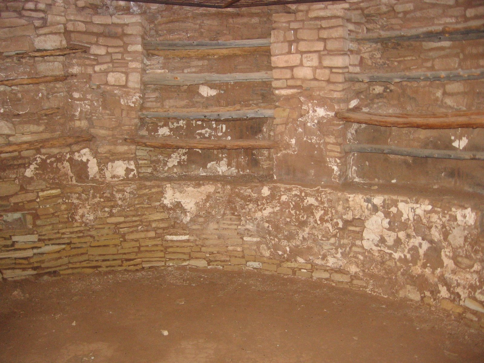
The highlight site is known as the Great Tower Complex on the northeast side of the pueblo. The large tower-kiva is 23 feet across and is part of castle like compact structure that may have been located to protect the spring water source for the area.

There may be several shrine structures along the east side of the site near the canyon rim, but we missed seeing them. The concept of shrine is somewhat vague and there aren't any interpreted shrine sites in the Mesa Verde area that I know of. They seem to be semi-circular east facing sites where offerings to the spirits or forces of nature are made.


The Great Tower Complex has been partially excavated several times but has been back filled such that no standing walls are visible. This complex appears to have built relatively late in the history of Yellow Jacket, around 1240-1280 AD)


There is some surface water visible below the cattails and there is some rubble visible near the spring. In addition to the springs as a water supply, there are the remains of check dams along the drainages to catch surface runoff.

Further down the same canyon, there are rubble piles below the rim. The structures protecting the water source are thought to be part of a trend in the mid thirteenth century as rising population put more demand on the resources. Along with the rest of the Mesa Verde region, Yellow Jacket was abandoned by about 1300 AD.


The Yellow Jacket site has a possible great house and great kiva on the north end of the site, outside the reserve boundaries and can only be viewed from a distance. It is thought that Chaco Canyon influenced people appeared here around 1080 AD.

There are several exact alignments at Yellow Jacket that are similar to the alignments found at Chaco Canyon.The total hike took 2:00 hours on late July morning.

18407_$5 Shipping on Orders of $99 or More! 544544_Travelation: More flights. Lowest price, guaranteed with no booking fees

Saturday, July 21, 2012

Lowry Pueblo Ruins


Lowry Pueblo Ruin is nine miles west of Pleasant View, in southwest Colorado on County Road CC and is toward the north end of the relatively new Canyon of the Ancients National Monument. The interpretive material on site draws attention to how this site compares to similar sites in the region.

The kiva enclosed by rectangular walls is a style that is also seen at Far View at Mesa Verde and the Escalante Pueblo at the Anasazi Heritage Center in Dolores.

The Lowry Ruin was excavated in the 1930s and is situated on the Sage Plain area, an area suitable for dry land farming and surrounded by deep canyons with Pinon Pine and Juniper forest. It is thought that the ruin was constructed beginning around 1060 and was occupied for about 165 years. 

The interpretive material describes how the site was built up during different construction periods. The different masonry styles used in different stages can be noted. Some of the features are thought to show influences of the Chaco Canyon style. The site is rectangular with the back wall facing the west and a separate Great Kiva across a plaza area to the east. 


The protective structure covers a kiva that was famous for the designs painted inside, though these have faded now. It is possible to enter the kiva through the low door and view the kiva from the bottom up.

The interior of the kiva shows some apparent racks made of wood. Similar features are seen in one of the kivas at the Coyote Village site in Mesa Verde. Kivas are usually interpreted as having ceremonial functions but I try to see them also as a way to deal with weather extremes, refuges from harsh temperature conditions.

The Anasazi Heritage Center in Dolores, CO has a preserved section of the Kiva designs and some large photos of what they originally looked like. There are also more details and pictures of the site. There were two styles of the designs that circled the kivas and these same designs are seen on pottery and petroglyphs around the region.

The Lowry Ruins site has a Great Kiva, one much larger than average. This one has unusual stone work features that are thought to be symbolic of the Winter People and Summer People. 


This is the only excavated Great Kiva in the nearby area. The Sand Canyon Pueblo Trail and the Goodman Point Unit of Hovenweep have unexcavated Great Kivas that are easy to view. 


There are other unpublicized ruins sites to look for in the Lowry Pueblo area. The Lowry Pueblo sits on a hilltop between two forks of Cow Canyon. The rims of the two forks are good places to look. There is also an unnoticed fairly large site along the entrance road to the Lowry site. (Use the Cow Canyon labels for more on these hikes.)

County Road CC continues west past the Lowry site for a short distance. I tried a short hike to the west from where the road makes a turn to the south. After about 0:15 minutes of climbing uphill through Pinon and Juniper forest I came to a sagebrush field that looked like it had burned near the east rim of Cross Canyon. There I found an elongated rubble pile site with many pottery shards and a line of turned on end flat stones, but nothing else in the vicinity.


532497_120 x 90 Starting Salary $42k. Group 1 18407_$5 Shipping on Orders of $99 or More! 544544_Travelation: More flights. Lowest price, guaranteed with no booking fees

Wednesday, July 11, 2012

Cahone Canyon Mesa Top


The Cahone Canyon Wilderness Study Area of the northeast part of the Canyons of the Ancients can be accessed with a west turn at County Road R at the small town of Cahone in southwest Colorado. From Highway 491 it is 4 miles to a gate and trail head.

The unmarked but obvious trail leads northwest about 1.5 miles to a junction with Cross Canyon. On this hike I stayed straight west along a vague trail next to the fence line.


It took me 1:15 hours to travel about 2 miles to the canyon rim overlooking the northern part of Cross Canyon. The fence line with the vague trail extends nearly the entire distance. There are two small canyon drainages to cross along the way. This point is about 1 mile south of where the main trail arrives at the bottom of Cross Canyon. 


Looking up and down the canyon, I couldn’t spot any Ancestral Pueblo Ruins sites from the mesa top. I could see some trail segments down below on the west side of the Cross Canyon bottom. On a previous hike to the canyon bottom I had found one ruins site slightly south of where the main trail enters Cross Canyon.


From this Cross Canyon view point I hiked south about 0.7 miles to the north rim of Cahone Canyon. There were two short side canyons to cross or walk around to arrive at the north rim. This south facing canyon rim had many large boulders that I thought would be likely places to find ruins sites. In the Cahone Canyon below looked like there was a permanent flow of water, but I didn’t notice any structures along the 1 mile closest to the junction with Cross Canyon. 


Walking back north, steering by compass, I came to a sagebrush area in the otherwise Pinon Pine and Juniper forest and started seeing many pottery shards and sharp edged rock pieces.


Looking around more, there is a fairly large village site that is largely overgrown with sagebrush. It looks like there has been some excavation is a few places here. There are several piles of collapsed building stone that have been moved away from the structures. Otherwise it is hard to see anything other than jumbled building stones.


This site is on the south side of the western most cleared field in this area. The cleared field and sagebrush show up clearly on the aerial photos on Google maps.


From this site I circled around the cleared field and walked northeast until I found the fence line I had followed from the trail head. I had spent about 3:30 hours and 4 miles looking around before finding this site. The return hike after looking around the site took about 1:00 hour. My total hike took 5:30 hours for about 6 miles. It was 70 F degrees at my 9:00 AM start and 88 F as 2:30 PM on a sunny early July day. I carried and drank 4 liters of water.


Thursday, July 5, 2012

Hilltop Village Between Yellow Jacket and Woods Canyon


The mesa top area between Woods Canyon to the west and Yellowjacket Canyon to the south has a variety of hidden Ancestral Pueblo ruins sites along the canyon rims and hilltops. From the Carbon Dioxide Gas Plant at the corner of County Road U and County Road 14, I traveled 1.4 miles south on Road 14 and stopped at a point where the road made a sharp bend to the west.

This road might also be labeled BLM Road 4528. This area is west of the community of Yellow Jacket along Highway 491 in the Canyons of the Ancients in southwest Colorado.


I hiked around the area on a warm early July day looking at the hilltops areas on both sides of the road. On the hilltop northwest of where I started there is a medium sized village completely hidden and overgrown with sagebrush and the Pinon Juniper forest.


On the east side of the site there is a large circular rubble pile in a volcano shape, perhaps a collapsed tower.


The next structure to the west seemed to be a more rectangular mound with less rubble visible. This site has good views from the hilltop overlooking the area to the south.


Further to the west is another circular ruin that I thought was more of a kiva, but none of these rubble piles had any visible walls that have held together.


From this village it is a short walk northwest to the nearest canyon rim where a boulder based ruins site is visible across and down the canyon. I think this site is also visible with binoculars from the main road about 0.5 miles further south. (The post for this boulders site is labeled Yellow Jacket Canyon Boulders.) 


I spent 1:30 hours on this hike even though the site I found was 5 minutes of walking from where I started. I was an 84 F degree early July day and I wasn't bothered by the biting gnats that are often a nuisance during June.