Monday, April 23, 2012

Stone Tools on the Trails

Hikes to the seldom visited Ancestral Pueblo ruins sites in the Canyons of the Ancients reveal pottery shards and small stones that could be tools. The Anasazi Heritage Center near Dolores, Colorado has interpretive displays to help understand these artifacts. While picking up and observing these objects in usually encouraged, they should be left where they are found.


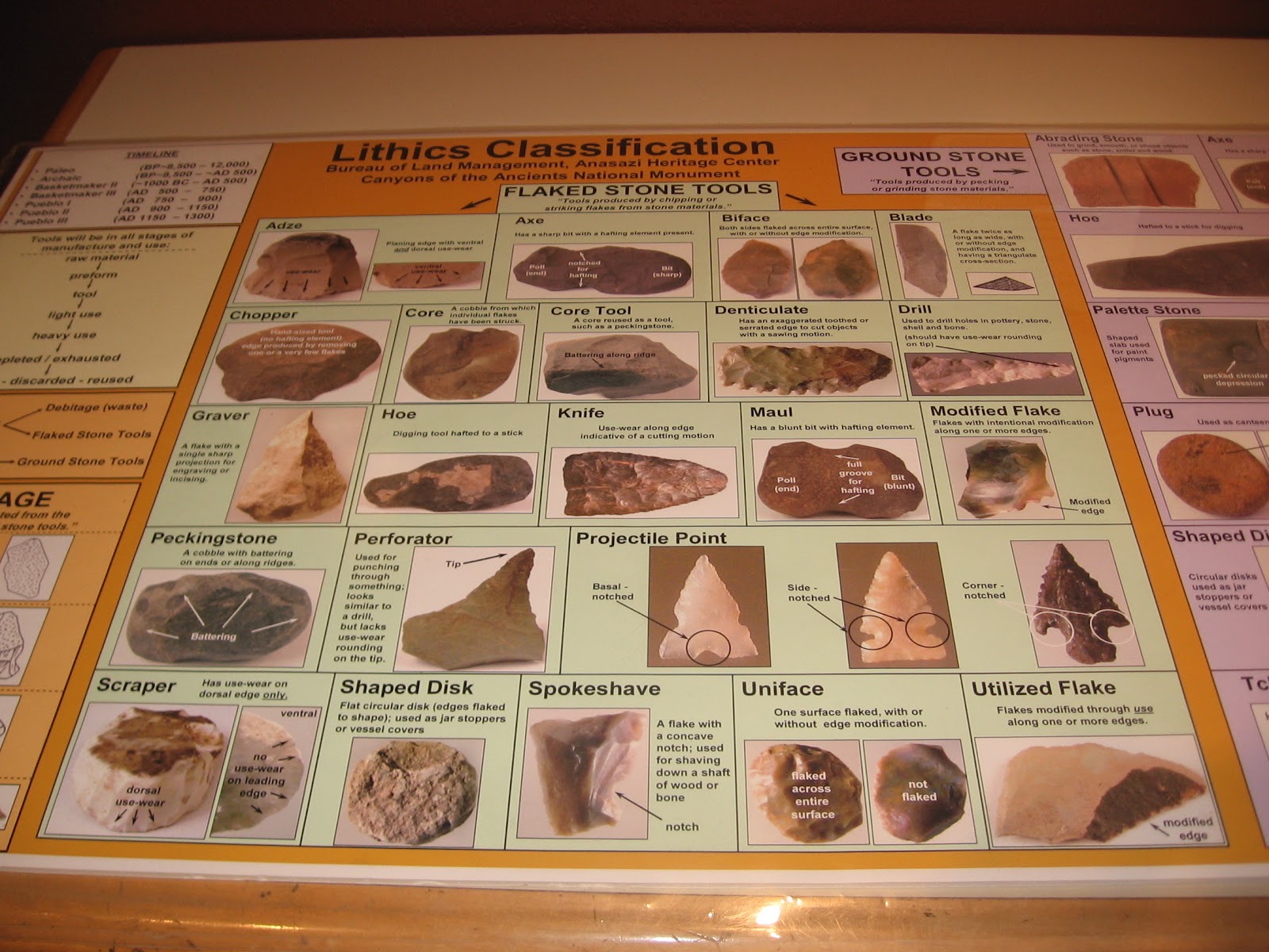
The Heritage Center display has 22 different types of lithics classifications, and this doesn’t include the large category of grinding stones. The stone pieces that I see are mostly not recognizable as a distinct shape, such as a projectile point, but many seem to have sharp edges or sharp points. 


Occasionally there are small hiker made arrays of stones near a ruins site. Glancing at them, it is obvious that there are several different minerals available.


None of these shapes are very distinct, but among the classifications are blades, gravers and perforators. 


In a drawer below the lithics classification poster, there are examples of the minerals that are available in the Canyons of the Ancients, both in a raw and finished form. The minerals on display include grayish Morrison Orthoquartzite, silvery Chalcedony, streaky Silicified Sediment and streaky Chert/Silicified Sediment, grayish Brushy Basin Chert, the reddish Jasper, and grayish Burro Canyon Orthoquartzite.


Chalcedony is described as a mix of quartz and moganite, two different crystal forms of silica dioxide. Chert seems to be a more general term for rocks that are quartz crystals but doesn’t include quartzite. Quartzite is a metamorphic rock that was originally sandstone and was altered due to pressure and heat. Orthoquartzite is very pure quartz sandstone. Jasper seems to be an impure form of Chalcedony and can occur in various colors due mostly to Iron.


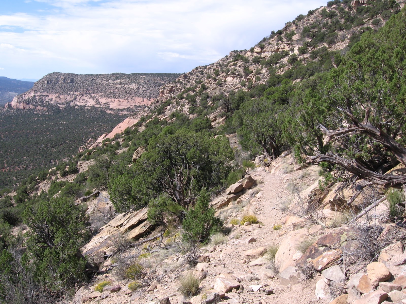
The Burro Canyon Formation and the Brushy Basin Member of the Morrison Formation are just below the Dakota Sandstone that forms the cliffs at the top of many of the Canyons of the Ancients. The trail guide for the Sand Canyon Trail has a diagram of these formations and they are exposed along the northern segment of the trail.


Another concept to consider when viewing these objects is Debitage, or waste flakes that are produced in making a useful tool.  One of the categories of waste flakes is called angular debris, a piece that breaks off while flaking by accident.


544544_Travelation: More flights. Lowest price, guaranteed with no booking fees

Thursday, April 19, 2012

Mockingbird Mesa NE to Sandstone Canyon


The canyons along the east rim of Mockingbird Mesa are part of the Sandstone Canyon system. From the usual starting area at the normally closed gate near the carbon dioxide facility it is a short walk to the east rim. Looking northeast from the rim, there is a wide and deep side canyon between the rim and a prominent rocky point.


Although it isn't clear from the distance, I had reason to believe that there is an Ancestral Pueblo ruins site on the rocky point. The Mockingbird Mesa area in the Canyons of the Ancients is 8.5 miles south on County  Road 12 from the junction with County Road BB, west of Pleasant View in southwest Colorado.

The route zig zags and the road numbers change before arriving at the normally closed gate. As the raven flies, the distance from the Mockingbird Mesa rim to the rocky point is close to 1 mile, but it looks like a difficult crossing and climb.


I started my hike 1.8 miles back north along the main road at a point where there is an old corral on the west side. My thought was that I could hike around the heads of the side canyons, or they would be easier to cross. From where I started it is about 3.5 miles to the rocky point, a longer hike but easier walking.


I found that it was possible to get around and across the side canyons from the corral starting point. I used a compass and started east, then southeast. There isn’t much visibility when hiking in the Pinon and Juniper forest without a trail, so a compass is valuable to maintain the direction. The carbon dioxide facilities are usually visible from along the canyon rims when the views open up.


The north facing boulder is the first sign that the rocky point is actually a ruins site. The remaining rubble and small fragment of a wall section are visible from a distance.


There is a large rock below the elevated boulder. I thought there was a semicircular level plaza in front of this rock outlined with some large stones.


The site on the rocky top is larger than it first appears. The rubble piles extend over most of the length of the level rocky surface. This site has one of the more dramatic locations with commanding views all around the area. Except for the north facing plaza, I didn't see any structures below the cliffs of the rocky top.


I always think it is interesting that these sites can see each other. From this high obvious view point, the ruins site that is near the carbon dioxide plant is in range as are the several sites that are below the east rim. There is also a boulder site 1.5 miles north of the carbon dioxide plant that can see this point. There might be a mesa top site in a cleared area to the north of this canyon site.


It took me 3:30 hours to arrive here, but I was walking slowly and scanning around a lot with binoculars. I visited the site for about 0:30 minutes. I had also walked out onto the point that is just to the west of this point. I spent about 1:00 hour looking around but didn't notice any ruins sites there.


The return hike also included a lot of scanning and slow walking and took 2:50 hours making this a long hike of 6:45 hours for about 8 miles. I carried and drank 3 liters of water on a mild 65 F degree mid April day.


18407_$5 Shipping on Orders of $99 or More!

Thursday, April 5, 2012

Mockingbird Mesa Northeast


The Mockingbird Mesa area in the Canyons of the Ancients is 8.5 miles south on County  Road 12 from the junction with County Road BB, west of Pleasant View in southwest Colorado. The route zig zags and the road numbers change before arriving at the normally closed gate near a carbon dioxide gas plant.


From the closed gate there is a way between the buildings to the east rim of Mockingbird Mesa. Turning north behind the plant there is a large rubble pile mesa top Ancestral Pueblo ruins site overgrown by sagebrush and the Pinon and Juniper forest. This is the easiest unpublicized ruins site to find in the Mockingbird area.
On this hike I continued north along the mesa top rim. A short distance north, there is a gap in the cliffs that allows an easy descent to the lower levels of cliffs. There is also the option to climb back to the highest cliff level. I chose to continue on a middle level, but not all the way to the canyon bottom. This canyon appears to be a side canyon of Sandstone Canyon. The hike I called Mockingbird Mesa Below the Rim finds some ruins sites in this same vicinity.

After about 1:10 hours of slow hiking, about 1.5 miles, there is a large boulder visible with rubble on top. I didn't see this until I was about 100 yards from it. It is visible from a much further distance from the higher levels of cliffs, but would be harder to approach from above.


In front of the large boulder, there seems to be a semi-circular retaining wall, forming what looks like a small plaza.

Most of the structure that was on the boulder top has fallen into the gap between the main boulder and an adjacent boulder. A small wall section encloses a minor alcove. This site looks like an isolated tower with a few features below, but not a village. From the boulder top area, it appears that there is a good line of sight with the large rubble pile site that is behind the carbon dioxide plant near the starting point.


There are some large boulders above the ruins site to climb for a view of the top of the ruins boulder. There are also two levels of cliffs above the site that can be climbed for better views of the canyon area.


I continued further north slowly for about 0:30 minutes and noticed a couple of places where there were stones piled to form a low wall. These walls didn’t seem to be associated with any other structures so it is puzzling what they are.

My return hike was along the highest level of cliffs. From here I could see the site I had just visited from a distance, but didn’t see any other sites in this area. My total hike took 3:50 hours for about 4 miles. I carried and drank 2 liters of water on a 65 F early April day.