Showing posts with label Lowry Ruins. Show all posts

Saturday, July 21, 2012

Lowry Pueblo Ruins


Lowry Pueblo Ruin is nine miles west of Pleasant View, in southwest Colorado on County Road CC and is toward the north end of the relatively new Canyon of the Ancients National Monument. The interpretive material on site draws attention to how this site compares to similar sites in the region.

The kiva enclosed by rectangular walls is a style that is also seen at Far View at Mesa Verde and the Escalante Pueblo at the Anasazi Heritage Center in Dolores.

The Lowry Ruin was excavated in the 1930s and is situated on the Sage Plain area, an area suitable for dry land farming and surrounded by deep canyons with Pinon Pine and Juniper forest. It is thought that the ruin was constructed beginning around 1060 and was occupied for about 165 years. 

The interpretive material describes how the site was built up during different construction periods. The different masonry styles used in different stages can be noted. Some of the features are thought to show influences of the Chaco Canyon style. The site is rectangular with the back wall facing the west and a separate Great Kiva across a plaza area to the east. 


The protective structure covers a kiva that was famous for the designs painted inside, though these have faded now. It is possible to enter the kiva through the low door and view the kiva from the bottom up.
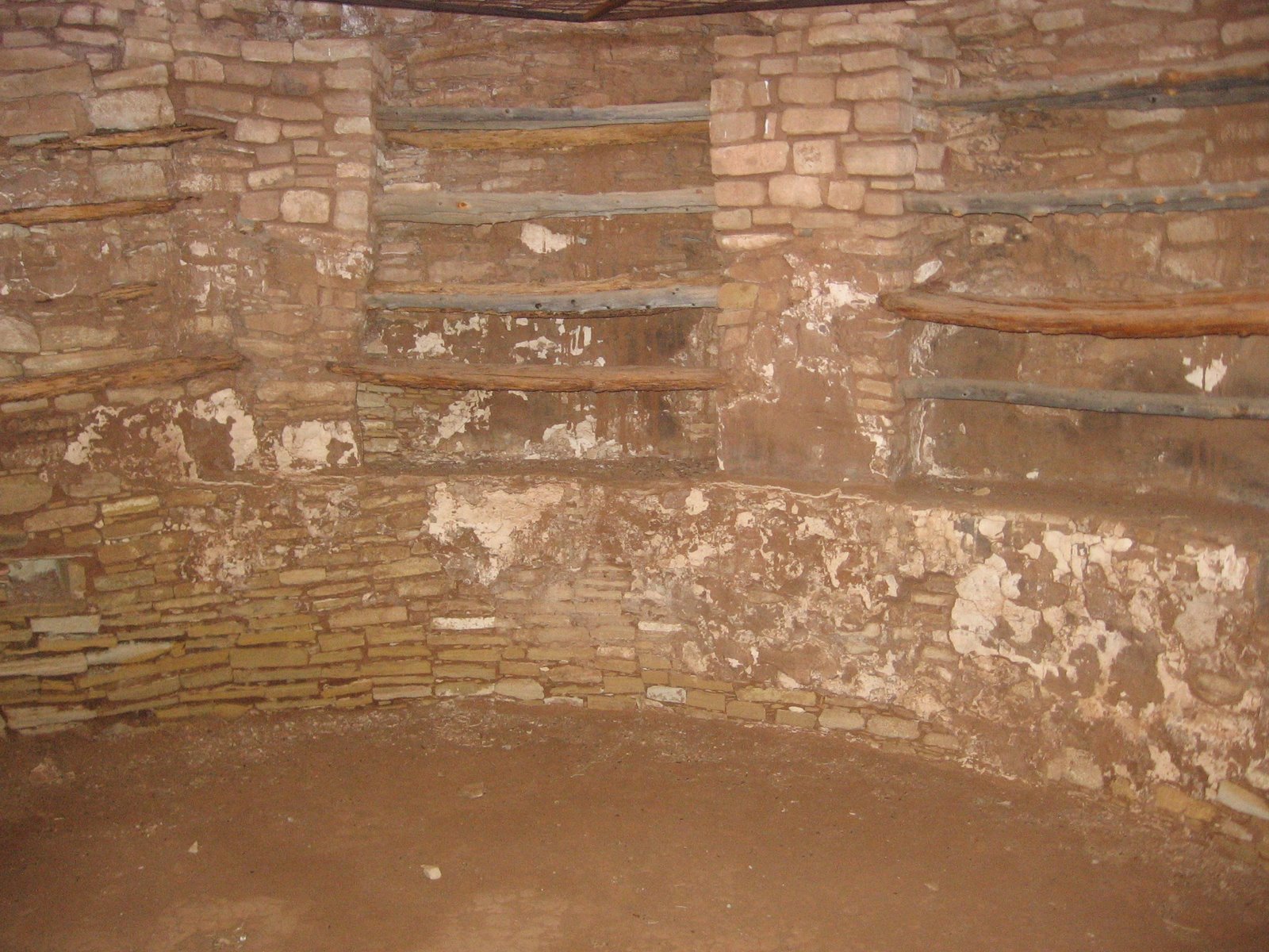
The interior of the kiva shows some apparent racks made of wood. Similar features are seen in one of the kivas at the Coyote Village site in Mesa Verde. Kivas are usually interpreted as having ceremonial functions but I try to see them also as a way to deal with weather extremes, refuges from harsh temperature conditions.

The Anasazi Heritage Center in Dolores, CO has a preserved section of the Kiva designs and some large photos of what they originally looked like. There are also more details and pictures of the site. There were two styles of the designs that circled the kivas and these same designs are seen on pottery and petroglyphs around the region.

The Lowry Ruins site has a Great Kiva, one much larger than average. This one has unusual stone work features that are thought to be symbolic of the Winter People and Summer People. 


This is the only excavated Great Kiva in the nearby area. The Sand Canyon Pueblo Trail and the Goodman Point Unit of Hovenweep have unexcavated Great Kivas that are easy to view. 


There are other unpublicized ruins sites to look for in the Lowry Pueblo area. The Lowry Pueblo sits on a hilltop between two forks of Cow Canyon. The rims of the two forks are good places to look. There is also an unnoticed fairly large site along the entrance road to the Lowry site. (Use the Cow Canyon labels for more on these hikes.)

County Road CC continues west past the Lowry site for a short distance. I tried a short hike to the west from where the road makes a turn to the south. After about 0:15 minutes of climbing uphill through Pinon and Juniper forest I came to a sagebrush field that looked like it had burned near the east rim of Cross Canyon. There I found an elongated rubble pile site with many pottery shards and a line of turned on end flat stones, but nothing else in the vicinity.


532497_120 x 90 Starting Salary $42k. Group 1 18407_$5 Shipping on Orders of $99 or More! 544544_Travelation: More flights. Lowest price, guaranteed with no booking fees

Thursday, January 13, 2011

Winter Footprints at Lowry Pueblo

Lowry Pueblo Ruins is located west of Pleasant View in southwest Colorado on County Road CC. It is one of the few easy to visit sites of Canyons of the Ancients National Monument. In the winter, the site is accessible but be prepared for deep snow. County Road CC is cleared of snow to the turn into the site. I parked at the beginning of the driveway and snow shoe hiked about 0.25 miles to the hilltop ruins area.


One of the several interpretive signs along the north side of the hilltop site is titled “Footprints.” It describes how the Great Sage Plain in southwest Colorado and southeast Utah was the most densely settled region of the Ancestral Pueblo world. 


We see mostly the large ruins sites, here, and at Mesa Verde, and other publicized sites, but there are many subtle sites hidden in the canyons and mesa tops in the Canyons of the Ancients area. The Hopi consider these sites to be footsteps of the ancestors. The Lowry site has views of all of the regional mountain ranges.


Lowry Pueblo is generally rectangular with doorways on the east side facing a plaza area that extends down to the Great Kiva. I noticed on the south side several lines of stones that seem to be glazed, or at least have a different color that were placed together. This southeast corner seems to clearly show a wall section that abuts the larger wall, rather than being tied into it.


The west wall doesn’t show any ground level doorways. On this side there is a line of small rooms that were entered from roof top entryways. The winds and weather systems in this region are mostly westerly; perhaps this arrangement offers protection from weather. The snow appears to really pile up on this side also.


It is possible to enter Lowry Pueblo on the east side to view the interior kiva. This kiva is famous for the painted designs that were on the interior walls. These paintings aren’t visible anymore, but there are pictures and a preserved section at the Anasazi Heritage Center near Dolores, Colorado. On the interior there are close up views of the interior stone work and passageways.

I spent about 1:30 hours on this visit on a 15 F degree sunny winter day. The mid January snow was about two feet and walking moderately difficult in most places. The entry road snow was somewhat compacted by a vehicle and was relatively easy walking.


Wednesday, August 4, 2010

Cow Canyon West of Lowry Ruins

The large mesa top Lowry Ruins is one of the featured sites in Canyons of the Ancients National Monument in southwest Colorado. It sits on a hilltop between two forks of the head of Cow Canyon and is the center a large community of outlying sites.

Near the parking area a primitive road heads south and allows hikers to explore for some of the surrounding sites. Lowry Ruins is located 9 miles west of Pleasant View, CO on County Road CC.

I hiked south of Lowry Ruins along the primitive road for about 0.5 miles, and then turned west to the east rim of the Cow Canyon west fork. Scanning with binoculars, it looked like there was a nearby alcove site below a canyon rim and further on I could see a rubble pile in a higher layer of cliffs. The alcove site was a little vague but there was a rubble pile under the cover of a shallow rock covering.


The rubble pile site was a little tricky to find, even though it was clearly visible from a distance. From above it was hard to get a good angle to view it, and several trees have taken root right in the middle of the site. It took me 1:00 hour of scanning and hiking to arrive at this moderate sized site.


From below, it appeared to be based on a large boulder with a lot of rubble having slipped off and formed a pile down below. I spent about 1 hour exploring the area around these two ruins sites. After viewing these sites I hiked slowly south about 1 mile along the east rim of the west fork to the point that overlooks the junction of the two forks of Cow Canyon. I didn’t notice any ruins sites along the way to the point.


This junction had very steep cliffs and a good view down Cow Canyon. I thought that the jumble of rocks at the point looked like a good location for ruins site but all the sites in this area appear to be closer to the canyon bottom in the east fork, which seems to have better southern exposure and was closer to the water source. Continuing back north along the rim I saw three likely boulder based sites well below the rim, close to the creek at the bottom. The northern most of these three sites I had visited before. On this hike, I only viewed these sites from the rim.

My total hike took 4:40 hours for about 4 miles. I carried and drank 3 liters of water on a 75 F degree day that had higher humidity than is typical in this area.


Monday, May 10, 2010

Cow Canyon East of Lowry Ruins

The Lowry Ruins site, 9 miles west of Pleasant View Colorado along County Road CC, is the center of the large Cow Canyon Ancestral Pueblo community. For this hike I navigated southeast about 0.5 miles through the Pinon Pine and Utah Juniper forest, looking for the west rim of the east fork of Cow Canyon.


There isn’t a trail to follow and I used a compass to guide my direction. The forest is open enough to hike through, with only the fallen Pinon Pines to avoid. I arrived at a point that is about 0.5 miles south and east of Lowry Ruin. From this view point I was luckily only about 200 yards up canyon from two large ruins sites, one on each side of the canyon. They are in this view, but mostly obscured by the forest.


I noticed the site on the opposite side of the canyon first. It appears to be a large rubble pile that is overgrown with sage brush. Looking at it with binoculars, I could see a small wall section below the rim in an alcove and more rubble on the slope below the rim.


The site on the west rim appears to be much larger. There are very large and extensive rubble piles on the west rim. This site is much like the interpreted Sand Canyon Pueblo site in size and appearance.


I found a notch in the cliffs to get below the rim. The site is as large below the rim as it is above. The slope is steep in spots and there is tangled vegetation in the way so the walking below isn’t very easy. There are at least two boulder top building sites, but I didn’t see any wall sections that had held together here. I didn’t try to cross the canyon to get to the site on the other side.


There is about 0.5 miles of west rim south of this large site to follow out to the lookout point overlooking Cow Canyon as it makes a swing toward the west. I noticed a possible collapsed tower site perched on a boulder about half way to the point and another more definite boulder top collapsed tower just before the point.

The view of the tower from the lookout point is good and it is possible to descend to get a closer view, but I didn’t go all the way down. This site appears to be isolated. I returned to Lowry Ruins on the dirt road that runs straight south from the parking area. I spent 2:40 minutes on this 2.5 mile hike on a 65 F degree early May day.

Thursday, February 4, 2010

Lowry Ruins in Winter

Lowry Ruins is one of the few easy to visit sites of Canyons of the Ancients National Monument in southwest Colorado. In the winter, the site can still be visited but bring your snowshoes.

County Road CC is cleared west of Pleasant View, Colorado but the driveway into the parking area and the trail to the ruins is not cleared of winter snows. It is about 0.25 miles of snow shoeing to get to the ruins area.

Lowry Ruins sits on a slight hill top with views of the sage plain area surrounding and all of the regional mountain ranges are in clear view. During my visit, it looked like a snow mobile had made a visit but there were no foot prints around the ruins site since the heavy snows of about 10 days before. The snow at the site appeared to average about two feet of depth. On a 30 F degree sunny day the snow surface was crusty and I didn’t sink in except for a few spots.

The interpretive information at Ancestral Pueblo sites doesn’t say anything about how the residents here would deal with heavy snows. It looks like snow drifts could build up high enough to block the low level doorways. Many of these structures had openings in the roofs with ladders, but how would that work if there was three feet of snow around the opening.

The farming areas are thought to have been worked with digging sticks, but I haven’t seen any mention of snow removal sticks. We mostly visit these sites in the warm months of the year and don’t consider the problems of winter survival. How many of these rooms were for storage of firewood and food for the times when conditions might be difficult for weeks.

The interpretive information at the site says that the Great Kiva at Lowry is considered to be a feature that drew residents to this site over several generations. It was a relatively early structure here, but there isn’t any comment as to why it was so attractive. The Lowry site is at a higher elevation than the pueblo sites in the Hovenweep area 20 miles to the south. The winter snows are deeper at Lowry and take longer to melt in the spring.

A large kiva like this seems to be a valuable feature for a community. It is big enough to accommodate a large group and has the earth contact and insulation features that might make a long winter more comfortable.

I spent about 1:30 hours on this visit on a comfortable winter day. I read at the Anasazi Heritage Center that some of the building stones at Lowry have petroglyphs inscribed similar to several that were found at the Escalante Pueblo. I circled around the site three times looking for them but didn’t spot any this time.


Lowry ruin in southwestern Colorado (Fieldiana : anthropology - Field Museum of Natural History, Chicago)

Friday, July 10, 2009

Lowry Ruins South to Cow Canyon

Lowry Ruins is a large Ancestral Pueblo ruins site and a main attraction in Canyons of the Ancients National Monument in southwest Colorado. It sits on an elevated site between the two forks of the head of Cow Canyon.

Near the parking area there is a dirt road leading south that offers a route for exploring Cow Canyon. Canyons of the Ancients has many small ruins sites but it is a find it on your own park.


The dirt road runs for about 1 mile with Pinon Pine and Utah Juniper forest on the east and a grassy sagebrush field to the west. About 0.7 miles along the way there are at least two small rubble pile ruins sites in the grassy area. They can be clearly spotted from the road.

Both the sites I saw had survey pins with site number tags attached. These two sites are small and it’s hard to see anything, but it’s good to find these early in a hike that doesn’t have a definite destination. Continuing on the dirt road until it reaches the forest edge. I made my way to a rocky point that overlooks the east fork of the head of the canyon.

I scanned the canyon rims and the bottom area and noticed that there are a few cottonwoods growing along the creek bottom and an area of sagebrush on the canyon floor as it swings to the west. I couldn’t see any Ancestral Pueblo ruins sites from the view point. There is a short side canyon on the west side of the point that is easy to get around and continue along the west rim of the Cow Canyon east fork.


There aren’t any trails to follow here. I walked through the mostly open forest looking for points along the rim that offered good views. About 0.5 miles further on I saw a rubble pile near the canyon bottom, close to the middle of the large sagebrush field that was visible from the lookout point.

The top of the canyon is mostly steep cliffs but there are many notches and gaps to get through the cliffs onto the gentler slope of the canyon side. This site used some large boulders as a foundation and seemed to be reasonably large, extending down the hill for a ways.

There weren’t any wall sections holding together here except for a short section that used large stones. This site is on a shelf that is well below the rim but above the canyon floor, and well above the creek. This site was visible from the rim right above it, but would be hard to spot from any other angle as the trees hide it.

Hikers approaching along the canyon floor would have to be looking into the forest area carefully. It is in the portion of the east fork that runs east and west for a short distance.


Since I was already down in the canyon I decided to return along the bottom rather than retrace my steps. This was a good idea but I made a navigation error and climbed out on the east side rather that the west side, fooled by a small side canyon to the east.

When I reached the top, I could see the protective structure of Lowry Ruins and headed north for it, but was surprised when I reached the east fork canyon again. The bright side of this mistake was that I came across the remains of an old log cabin down below and was able to see the east fork of Cow Canyon from another angle.

I found a cow path that led back down and then up and crossed again. It took me about 2:00 hours to find the Cow Canyon east fork site and 2:00 hours to return for a 4:00 total hike for about 3.5 miles. It was an 84 F early July day with a good breeze blowing and I carried 2 liters of water.