The Cross Canyon access road is 2.7 miles northeast of the turnoff to the headquarters of Hovenweep National Monument along paved County Road 10, along the Utah and southwest Colorado border. The access road is marked as San Juan County 2031 and turns west descending steeply for 2.3 miles down into Cross Canyon.
At the bottom there is a creek crossing. Just past the creek there is a right turn that enters Cross Canyon and heads toward McLean Basin and the Cross Canyon Wilderness Study Area. The trail I followed is about 1.2 miles up this road on the left. It is clearly visible while descending into the canyon. This rough uphill road connects to other roads on top of Squaw Point. This area is slightly outside the official Canyons of the Ancients, but still BLM managed land.
I’ve started up this trail before but turned back about halfway up due to biting gnats. Continuing to the mesa top, there is a side road that turns south. I followed this route to the end of the trail. After about 1:00 hour of hiking the trail ends and a large boulder based ruins site is visible further south. It took me another 0:20 minutes to arrive at the site. There are two short side canyons between the end of the trail and the ridge location of the boulder ruins.
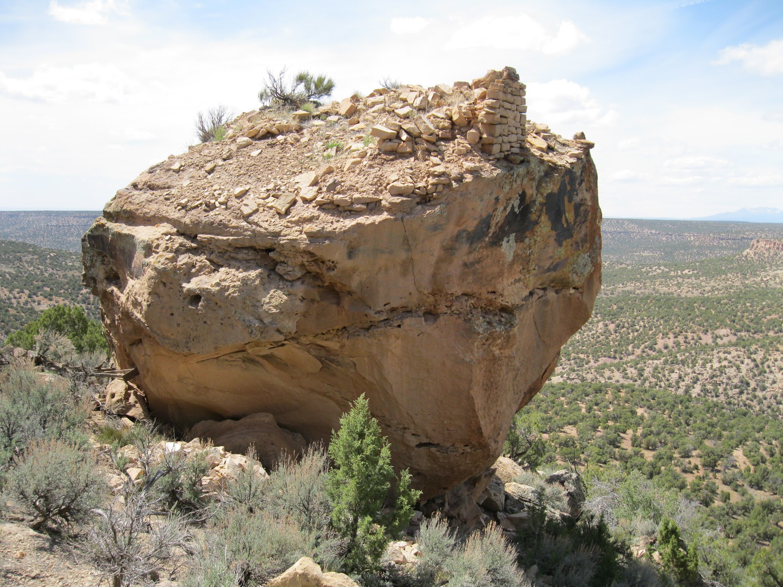
There is a lot of rubble on the top of the boulder, but only fragments have held together as walls. This site has one of the most dramatic of locations. It is on the point that overlooks the very broad junction of Cross Canyon and Squaw Canyon. The rocky point location is visible from miles around but it is not obviously a ruins site from a long distance view.
Most of the interesting features are along the east side. There are two small sections of wall structures that have been sheltered with some brick fragments visible above.
Further on there is a kiva depression with some wall brickwork visible. There were many pottery shards around the kiva.
The largest and most conspicuous pottery shards were white with black smudges. This style seemed unusual. There were also corrugated and a few painted designs.
Further on there is a large circular rubble pile. The sides of the boulders are tall and very vertical and I didn’t notice any easy way for the residents to climb to the top.
I noticed three petroglyph panels. One of them had some very clear and interesting images. There is a good image of a hunter with a bow and arrow aiming at a mountain sheep.
On the left side of the same panel are two reclining figures, one playing a flute. I can’t tell what the other figure is doing. The pair seems to be enclosed in a frame.
Looking back north along the east rim of Squaw Canyon, I think another boulder based site with wide views is visible two or three miles away. The Squaw Point road leads close to that site. It is interesting that these two sites have a very clear line of sight. My return hike took 1:10 hours and the total hike was 3:15 hours for about 5 miles. I carried and drank 2 liters of water on a sunny 68 F degree mid October day. The sunny mild days of fall are probably the best time of year for hiking in the Canyons of the Ancients.
Trails visiting Ancestral Pueblo Ruins in the canyon country along the southern Utah-Colorado border. Includes the remote sites of Hovenweep National Monument, the relatively well known Sand Canyon Trail system, and many wild hikes to little known hidden sites. Notes and Pictures. Hike for fitness and environmental awareness.
Showing posts with label Squaw Point Mesa Top. Show all posts
Friday, October 14, 2011
Friday, April 22, 2011
Squaw Point Mesa Top
The Squaw Point Mesa Top is the area between Cross Canyon on the east and Squaw Canyon on the west, in the Canyons of the Ancients in soutwest Colorado. The access is to follow paved Road 6 south from Dove Creek, CO. The route zig zags west in several places but continues south on Roads 5 and 4. The Canyons of the Ancients area definitely begins at a cattle guard after about 17 miles.
At about 19 miles, the well maintained county roads end at a drill site, but a dirt BLM road makes a right turn and is marked with a National Monument sign. The dirt road is bumpy but is drivable. It is marked as a “Designated Route” for motorized travel. I continued driving 2 more miles down this road. There are several side roads along the way, but I only saw one side road that was also a Designated Route.
At about 2 miles down the dirt road, there is a short turn off that provides some good views of Squaw Canyon. The area in view is in the Squaw/Papoose Canyon Wilderness Study Area. It appears to be over the state line into Utah, but still part of the BLM managed lands.
I was surprised to see what I think is a Navajo Hogan type structure built into the canyon rim. The doorway may be oriented south rather than the traditional east. The roof uses cribbed juniper logs, but has some plastic sheet built in.
Overlooking the Hogan to the south, there is a boulder based ruins site visible about 0.4 miles away. This site isn’t visible from the road. I drove a little further south and hiked to it, but the hiking distance is about the same whether you drive further or not.
The boulder is located just below a point and has a commanding view below, across, and to each side. There is a small section of still standing wall segment.
Most of the rubble appears to have fallen on the south side. There is an old but modern ladder among the debris. My side trip hike here took about 0:40 minutes.
Coincidentally, at the point where I parked about 0.4 miles south of the Navajo Hogan, there is a mesa top ruins site very close to the road. Though it is visible from the road, it is overgrown with sage brush. This mesa top site was about 100 yards from the canyon rim and about 0.4 miles from the boulder lookout ruins site.
The road continues south through a large sagebrush field. I stopped at a random point and walked about 0.3 miles to the Cross Canyon west rim. Cross Canyon continues to the McLean Basin area. In the southwest side of McLean Basin, there is a rough road that climbs up and probably connects to this mesa top road, but I didn’t get that far. I stopped at a fence and gate that was 4.2 miles past the Canyons of the Ancients sign.
Subscribe to:
Posts (Atom)