Showing posts with label Sand Canyon-East. Show all posts

Sunday, November 29, 2009

Horse Trails East of Sand Canyon

Along the south and east edge of Canyons of the Ancients National Monument near Cortez, CO, there are many rock alcoves visible from the County Road G where access is blocked by private property.

The only access for hikers in this area is the Sand Canyon Trail. There are horse trails that lead to the area east of the main Sand Canyon Trail but for a hiker it is a fairly long trek.


The most distant Ancestral Pueblo ruins site that seems to still be in hiking range is located more or less behind the Kelly Place Bed and Breakfast, maybe 1.5 miles east of the Sand Canyon Trail Head. There are two possible routes to get to this relatively large site. The longer way is to follow the main Sand Canyon Trail about 3.3 miles to the small sign that says “Sand Canyon”, then turn east off the trail and follow the unmarked East Sand Canyon Trail past three side canyons until it intersects with the drill hole service road.

Follow the drill hole road past the Mad Dog Tower site a few hundred yards to a vague two track trail. Then continue east to the small pipe lines that shoot up to the top of the mesa. There is another horse trail a few hundred yards south along the pipelines that crosses the pipelines and leads another mile or so to this site.

On a previous hike it took me 2:30 hours to get to Mad Dog Tower using the main trails and it is another 0:30 minutes to get to this eastern site. The 3:00 hours assumes that there is no stopping at the 20 or more ruins sites along the way.

An alternate way is the Mouth of Sand Canyon route that is shorter, but includes scrambling down and up the side canyons near the lower end of Sand Canyon. Climbing in and out of these side canyons is feasible, but the route isn’t marked.

There is a good alcove site in the eastern side canyon with a lookout point ruin above the alcove. The upper end of the east side canyon is near the drill hole road and a few hundred yards south of the Mad Dog Tower. From the drill hole road, find the horse trails and continue east.

The horse trails that cross the area east of Mad Dog are well marked and look like they get a lot of use. The horses seem to have an access point in the private property that is not available to hikers. The main Sand Canyon Trail area is dominated by hikers and mountain bikers, but the eastern area is the domain of horse riders.

A few hundred yards south and east of Mad Dog Tower there is another circular structure that has a dead Juniper tree in the middle of it. I missed this site when I was hiking east from Mad Dog Tower on the previous hike. It is close to the horse trail but not very near the rock face where I was looking at the alcoves.

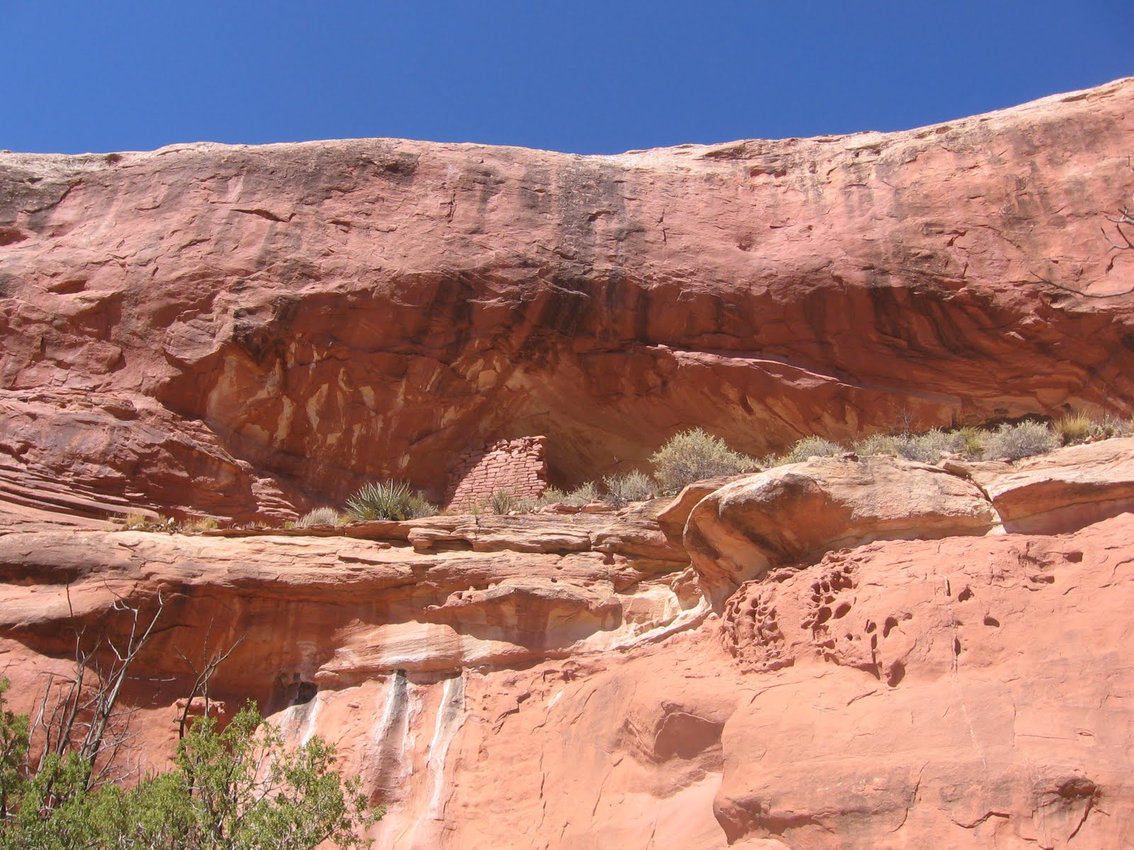
The horse trail passes around the upper end of a deep side canyon and several empty alcoves before arriving at the site. There is a trail up to the site on the left side that enters on the left end. It looks like there are remains of three separate structures with the largest at the right end. The large structure on the right still stands tall with details of the doorway construction still visible.


I followed the Mouth of Sand Canyon route both out and back and stopped at the mouth alcove ruins and the lookout ruin above it. With another short stop at the circular neighbor of Mad Dog Tower, it took me 3:00 hours to arrive at this site. My return hike without stops took 2:00 hours and my total hike was 5:15 hours for about 6.5 miles on a 55 F blue sky day in late November. I carried and drank two liters of water.


Sunday, October 4, 2009

Mouth of Sand Canyon Trail

The Sand Canyon Trail in Canyons of the Ancients National Monument, in southwest Colorado, runs 6.5 miles north and south on the west side of Sand Canyon and passes many small Ancestral Pueblo Ruins sites.

About 3.3 miles up the trail there is a side trail to the east side of Sand Canyon that leads to several more sites. One of these sites is in a side canyon that is back toward the south end of Sand Canyon near the canyon mouth. (In 2011, this area off the Sand Canyon Trail might be considered closed.)

On this hike I was looking for a route across Sand Canyon that was closer to the south trail head. The south trail head is 12 miles west of Cortez along County Road G. From the south trail head I hiked about 0.5 miles to the end of the first spur trail on the west side. There is a distinctive rock formation at this point.
From there I hiked east for another 0.5 miles through the Pinon Pine and Utah Juniper forest to the edge of Sand Canyon. From the canyon rim the ruins site I was heading for is visible in the side canyon on the east side. At the view point the canyon is very steep and deep.
Back to the south a short distance there is a side canyon on the west side that offers a possible route into the main canyon. This side canyon has its own side canyon on the north and I was able to find a way there down to the bottom. Near the bottom I spotted a rebar stake that looks like something the archaeologists install to mark a site. There was a south facing alcove in the vicinity but I didn’t see any obvious ruins.

Once reaching the side canyon bottom the walking is fairly easy toward the main canyon. In the main Sand Canyon there is a vague horse trail leading up the canyon. At first, from above and below it is hard to see how anyone entered this site. It is a total hike of about 1.5 miles to get to the point below the ruins site.

After viewing the site from below, I looked to see if the East Sand Canyon area could be reached by climbing out of this side canyon. It is possible to climb to the east canyon rim area going up the east side canyon. The route requires a little scrambling but is not too bad. I climbed up the south side of the canyon before reaching the canyon head. From above, I could see the ledge that offers a route toward the alcove. It looks like there is a section just before the alcove that might be treacherous.

It also looks like there is a ramp leading to the rim from the ledge. On a later hike, I walked up the ledge and was able to enter the ruin. There is a notch that allows climbing into the site. I looked at the ramp and it looked too risky for one person to try alone. Perhaps two persons together could help each other up.

Looking back at the alcove from up the canyon I had noticed a wall fragment above it and to the left. I don’t think this wall section is visible from the west side angle. It looks like a castle rock type of site is above.

On the later hike I climbed out of the canyon on the north side near the canyon head and was able to get closer to this site. The wall section appears to be part of an isolated lookout tower. I didn’t see any other structures up on top. It is possible to climb in or out of the east side canyon on either the north or south sides, but there isn’t a marked route.

From this area it is about 0.25 miles east to the drill hole service road and the vicinity of the sites near and east of the Mad Dog Tower site. I returned to the main trail head using the 1.5 mile drill road route, but this road passes through a short section of private property.

My total first hike was about 3 miles and took 3:00 hours on a 70 F degree early October day. The revisit hike was on a 50 F degree day in late November and I spent some time getting closer to these two sites.


Friday, September 25, 2009

Mad Dog Tower Trail

The Mad Dog Tower is in the Sand Canyon area of Canyons of the Ancients National Monument in southwest Colorado. It is vaguely visible east of the Saddle Horn Ruin along the 6.5 mile Sand Canyon Trail about 1 mile north from the South Trail Head.


I started my hike at the South Trail Head and walked about 3.3 miles north past the last of the 10 or so small ruins sites in the lower part of the canyon. As the trail passes a small sign that says “Sand Canyon”, an unmarked side trail that I call the East Sand Canyon Trail turns back south on the east side of the canyon. The East Sand Canyon Trail passes by three side canyons that have at least seven more small ruins sites. (In 2011, this side trail off the Sand Canyon Trail is considered closed.)

The East Sand Canyon Trail exits at the head of the third side canyon and connects to the drill hole service road. The Mad Dog Tower is very close to the east side of the road. I walked right past it when I hiked in this area before, but it can be seen from the road. Excavation work on this site found a room block, an earth walled kiva with a tunnel and a trash pile midden, but these features aren’t visible on the surface.

I saw a story that the students working on the site were chased by dogs as they traveled to the site every day and named the site Mad Dog in honor of these dogs. It took me 1:30 hours to cover the 3.3 miles to the beginning of the East Sand Canyon Trail and another 1:00 hour to arrive at the Mad Dog site. I didn’t stop to view any of the other sites along the way on this hike.

While in this area I explored the alcove areas to the east of Mad Dog. The first area to the east had a small alcove to the left, a larger one in the middle and another large on the right. I could see a small wall section in the smallest of the three possible locations.

There is a hikeable route along the left near the sandstone wall. The interior of the small opening appeared to be covered with soot. The other two alcoves in this area appeared to be empty.

Further east there are some odd pipes approaching from the south that shoot right up to the top of the mesa. These are probably associated with the gas plant that is east of the trail head area. It looks like horse riders use the pipeline route as a trail. There are one or two small sites in the area to the right of the pipelines.

A rough trail leads from the pipes across this rubble strewn area toward the small wall section on the left side of the formation. There is another small wall fragment directly across on the right. This site is about 0.5 miles east of the Mad Dog Tower. I turned around here and followed a two track road that connects back to the drill hole service road at a point a few hundred yards south of the Mad Dog Tower. There are more alcoves and possible ruins sites to the east of where I stopped.

I followed the drill hole road back to the connection with County Road G that is 0.5 miles east of the trail head parking, slipping through a section of private property. There is a locked gate along the drill hole road that prevents motorized access to this area of Canyons of the Ancients. After the 2:30 hours to arrive at Mad Dog I spent 1:00 hour exploring to the east and the return hike took 1:00 hour. My total hike was 4:30 hours on a 70 F degree day in late September. I carried two liters of water.


Saturday, September 12, 2009

Saddle Horn Ruin Neighbors

Saddle Horn Ruin is one of the small Ancestral Pueblo Ruins sites on the Sand Canyon Trail in Canyons of the Ancients National Monument in southwest Colorado. There are at least two off the trail ruins sites that can be viewed from a distance in the vicinity of Saddle Horn. (In 2011 the off trail areas are considered to be closed.)

The south trail head for the 6.5 mile Sand Canyon Trail is 12 miles west of Cortez, CO on County Road G. The Saddle Horn Ruin is about 1 mile north along the well marked trail. Turning off the trail and going east and slightly north for a about a quarter of a mile to the rim of Sand Canyon. I scanned with binoculars across to the other side looking for a tower site known as Mad Dog Tower.

I didn’t see anything from the rim but moving back to a higher spot and repeating my scan several times I finally spotted the elusive tower. It is visible in line with the right side of the large rocky outcrop that is in the middle of this view. It appears to be only about a half mile away but Sand Canyon is very deep and steep and in the way. (I think the Mad Dog Tower can be sighted from the Saddle Horn ruins without leaving the Sand Canyon Trail.)

There is an unmarked East Sand Canyon Trail that accesses the area of Mad Dog Tower. Follow the Sand Canyon Trail north for about 3.3 miles to the point where there is a small sign that says “Sand Canyon.” The main trail continues north, but there is also a trail that crosses and turns south toward the side canyons on the east side.

On this hike I tried walking south along the west rim of Sand Canyon to see if there was a shorter route over to the east side. There is a service road for drill holes on the east side but it passes through private property.

I walked to a point that is about 0.7 miles east of the Castle Rock Pueblo and overlooking the beginning of the drill hole service road.  Looking back north up the canyon I spotted an alcove ruins site that looks like it is in a very inaccessible position. This site is in a short eastern side canyon near the junction of Sand Canyon with McElmo Canyon. There are cliffs both above and below the site and there isn’t any apparent entry point.

I thought this would be a rarely viewed site but I caught a glimpse of it as I drove past the canyon mouth on County Road G. From the view point it was about 0.5 miles across country back to the Sand Canyon main trail and then 0.5 miles back to the trail head. My hike was about 3:00 hours for 3 miles, with much of the time spent scanning for these elusive sites.


Tuesday, July 21, 2009

East Sand Canyon Trail

The Sand Canyon Trail is a 6.5 mile north and south route in Canyons of the Ancients National Monument in southwest Colorado. It runs along the west side of Sand Canyon passing at least 14 Ancestral Pueblo Ruins sites. There is an unpublicized trail on the east side of Sand Canyon that allows access to several more sites. However, in 2011 I think this side trail is considered closed.


I started my hike at the South Trail Head, located about 12 miles west of Cortez, CO along County Road G. I walked about 3.3 miles north, skipping past the Castle Rock Pueblo and the 10 ruins sites that are easy to visit along the short spur trails. At the point where the trail actually dips into the canyon bottom, there is a small sign that says “Sand Canyon.” The East Sand Canyon Trail takes off to the east in the vicinity of the small sign, but there is no marker. It looks like this is a horse trail.

On a previous hike that I called “Sand Canyon East Rim Exploring” I had started at the North Trail Head and climbed out of the canyon bottom a few hundred yards north of this point onto the shoulder where there is a drill hole service road. The East Sand Canyon Trail allows a close up view of the sites that I had previously viewed from a canyon rim above.

The East Sand Canyon Trail turns back south and passes by three side canyons that hold small ruins sites. The trail is on the shoulder above the canyon bottom, just as the main Sand Canyon Trail is. The first side canyon is the one that I had viewed from above previously and has five sites, all in south facing alcoves. The trail doesn’t go directly past these sites and there isn’t a spur trail that I could find. The first site is one that I called the 5th site when I viewed them from the upper end of the side canyon.

The fifth site has the most material still standing, and there are some circular wall sections in the area in front of the alcove. The nearby 4th site has two short sections of wall remaining. The 3rd site is mostly just the alcove with some rubble piles.

The 2nd site is the second best of this group, with an intact small structure to the left and some wall fragments on the right. There is some rubble in the middle in the middle of the alcove.

The main East Sand Canyon trail continues to the south to the second of three side canyons. The second side canyon had one site. This one is the most visible when scanning with binoculars from the main Sand Canyon Trail.

It sits up high with steep slopes in front. I looked around for an easy way up but didn’t see one so I just viewed from below. All of the vegetation made it hard to get a good angle for a close up picture. From below, it looks like this site is the best preserved of any of the small sites in the Sand Canyon area.

The third side canyon also has one alcove site. From the distance, it looks like there is only a small wall section standing on the left. This site is easy to enter and is more interesting from the inside.

There are several low walls on the inside and the cool shady inside of the alcove was pleasant to sit in as the summer afternoon heat built up. As I was sitting there resting I noticed a petroglyph on the left side wall outside the alcove.

The petroglyph was only two spirals and some sharpening notches, but there aren’t many petroglyphs in the Canyons of the Ancients area. The Holly Group in the Hovenweep area has a solstice panel and there is a large panel near Ismay, but those are the only other two that I know of.

It took me 3:30 hours to get to the third side canyon petroglyph site. From here a hiker can either retrace back to the trail head or continue south on the drill hole road that runs along the east side of this side canyon.

I took the drill hole road, but it eventually leaves the Canyons of the Ancients territory and passes through private property. It reaches County Road G about 0.5 miles east of the Sand Canyon Trail Head. My total hike for about 8 miles and 6 ruins sites took 5:15 hours. It was 70 F degrees at 8:30 AM in mid July and mostly cloudy with some breeze but cleared off and was about 90 F at 1:45 PM when I finished. I carried 3 liters of water and drank it all.


Monday, March 9, 2009

Sand Canyon East Rim Exploring

The Sand Canyon Trail is a 6.5 mile north and south route in Canyons of the Ancients National Monument, about 12 miles west of Cortez in southwest Colorado. The main trail runs on the west side of Sand Canyon and visits small Ancestral Pueblo ruins sites.

From the middle part of the main trail there are several alcove sites visible with binoculars across on the east side of the canyon, but the trail doesn't go over there. I started my hike at the north trail head to try to view some of these sites. However, in 2011, this area east of Sand Canyon is considered closed.


The second mile from the north trail head is steep with many switchbacks and descends 680 feet to the canyon bottom. Visible to the east are two drill holes, disturbed areas, with a service road connecting them.
Just north, this side, of the drill hole site there are two small side canyons that are options for climbing out of the lower canyon and getting up to the drill hole level. I used the more northern of the two choices and was able to climb out without too much trouble.  Crossing over to the service road, I followed that around to the south side the first large side canyon to see if any ruins sites are visible.
The large side canyon has two canyon heads with a peninsula in between. Viewing from the rim, there are two small sites at the upper end of the side canyon. This view is the second site. The environment here is Pinon Pine and Utah Juniper forest.
There are five sites spaced out along this south facing canyon wall, all associated with alcoves. This view is of the third and fourth sites. From the main Sand Canyon Trail, there are more side canyons with ruins sites visible to the south of this one. These alcoves are in the Entrada Sandstone. The trail guide helps identify the numerous geologic layers visible here.

The fifth site looks like the best of this group. This one can be vaguely seen with binoculars from the main Sand Canyon Trail. I took about 3:00 hours to get to this view point, including my stops and 2:00 hours to return up the steep trail to the north trail head. My total hike was about 5:00 hours for about 7 miles.