Showing posts with label Yellow Jacket-Lower. Show all posts

Sunday, August 26, 2012

Lower Yellow Jacket Canyon at Ismay


The Yellow Jacket Canyon makes a junction with McElmo Canyon 26 miles west of Cortez along County Road G near the border of Colorado and Utah. Yellow Jacket Canyon Road is a rough trail that turns north at the old Ismay Trading Post along the west flank of Cannonball Mesa. This area is the southwest corner of the Canyons of the Ancients National Monument.


There is an unpublicized ruins site with petroglyphs only 0.2 miles along the rough road. About 0.1 mile past the ruins site there is a side road that leads left  toward the Yellow Jacket Creek.


The side road cuts through the thick Willow, Cottonwood and Tamarisk riparian habitat along the creek to an easy hiker crossing point. In late August there was about 1 foot depth of water and a fairly swift flow. There was a surprising amount of water here considering how dry the surrounding landscape is and that 2012 has been a relatively dry year. I carried river sandals to make this crossing.


After the crossing, there are cow trails to follow toward the mesa area that is about 1 mile to the northwest. This area is very vegetation free and walking is easy. 


With binoculars, a small ruins site is visible on a ledge one layer of cliffs below the mesa top. I had sighted this ruin on a previous hike from the east side of Yellow Jacket Creek.


I didn’t see an easy way to get on the ledge, but the ruins can be viewed from several angles. From the left side, there is a large front wall that is visible from a long distance and a smaller wall section perched above it.
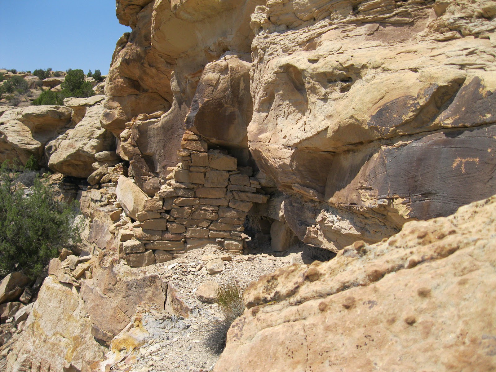

From the right side, there is another wall section with a small doorway. I didn't see any other structures associated with this ruin.


On the right side, it looks like hand and toe holds lead to the mesa top. I didn’t try to climb up there but there must have been a mesa top route on top to get to this structure.


Looking back at lower Yellow Jacket Canyon, the ruins site close to Ismay is visible as is the Cannonball Mesa top. Slightly to the north, there is a ruins site that overlooks the junction of Hovenweep and Yellow Jacket Canyon that is not visible from here. It took me 1:00 hour to arrive at the ruins site starting from close to the creek crossing. The slow part is climbing up the slope.

The return hike took 1:15 as I walked north a little more are scanned up the canyons with binoculars. My total time was 2:30 hours on an 85 F degree late August day. On a warm day I carried and drank 2 liters of water.


Sunday, March 20, 2011

Cannonball Cliffs to Yellow Jacket Creek

The north cliffs of Cannonball Mesa overlook the lower section of Yellowjacket Canyon in the southwest part of the Canyons of the Ancients National Monument in southwest Colorado. The west end of Cannonball Mesa is 26 miles west of Cortez, CO on County Road G to the rough Yellowjacket Canyon Road at Ismay Trading Post.


The unmarked cow trail that provides an easy route to the top of Cannonball is 1.4 miles north along the rough road. At the top I turned left or north, and continued along the rim, past a narrow northwest point to an overlook of a boulder based Ancestral Pueblo ruins site. Slightly to the east, there is a notch in the cliffs that allows a descent down the slope.

I had spotted this site on a previous hike along the Cannonball Mesa Cliffs. The notch has several easy to view petroglyphs near the rim. It took me 0:45 minutes to arrive at the notch.
 

The hike down the slope is somewhat slippery but feasible. The best routes are often easier to see looking up the slope rather than down. At the ruins site, there are some minor wall sections still in place around the edges on top and much rubble has tumbled down on the south side.


 I didn’t see any other structures around the boulder. From this site it is an easy walk down toward the canyon bottom and the flowing creek and there are many other large boulders in the vicinity.

One of the large boulders about 100 yards to the west has a clearly visible horse image sitting above a faint but larger horse. This panel faces the canyon bottom area.

At the canyon bottom there is a continuation of the Yellowjacket Canyon road, but direct access is blocked by private property. This section of the canyon bottom is part of the Canyons of the Ancients for about 1 mile. Many other segments of Yellowjacket Canyon bottom are private property.

I followed the old road, walking slowly and scanning the opposite side with binoculars. In about 20 minutes of direct walking, the road leads to the creek and dead ends. I didn’t spot any ruins sites in the creek area, but they are often hard to see from a distance. During my hike, there was an old backhoe parked at the end of the road.


I was 3:10 hours into my hike when I arrived back at the ruins site on my return hike. I saw a few alcoves high to the west and wanted to see if there was another route to this area. When I climbed to a ridge below the alcoves I had a major surprise. (Go to the next post for the surprise.) Otherwise, my total hike took 4:10 hours on a 60 F degree partly cloudy and windy mid March day. I carried and drank 2 liters of water for about 5 miles of hiking.


Hovenweep and Yellowjacket Junction

The northwest corner of Cannonball Mesa overlooks the junction of Yellowjacket and Hovenweep Canyons in the Canyons of the Ancients National Monument, near Ismay Trading Post in southwest Colorado.

After visiting a small ruins site along the north Cannonball Cliffs rim hiking route I looked for an alternate route back to the mesa top.


I was so stunned when I came over a small ridge that I gasped aloud. Besides being surprised by this ruins, this site has an impressive location that sits with a perfect view down Yellowjacket Canyon and up Hovenweep Canyon.

 There are many boulder based ruins sites in the Canyons of the Ancients, but this one seems to be perched on a perfect cube and has several clearly visible rooms.

I saw one large petroglyph image on the boulder foundation and a small spiral. I could see the Yellowjacket Canyon road and my parked car from this site. It is visible with binoculars from down below, but is hidden when hiking along the rim. I didn’t find an easier return route than the way I came.


Thursday, April 8, 2010

Risley Canyon to Yellow Jacket Canyon Village

Risley Canyon is a tributary to Yellow Jacket Canyon in the south central part of Canyons of the Ancients National Monument in southwest Colorado. The trail head that I used to explore this area is 3.4 miles north on the BLM road that is 20 miles west of Cortez, CO along County Road G.


This starting point is high on the south side before descending into and crossing Risley Canyon. It is a little north of the starting points for hikes to Cannonball Mesa and the Lucy’s Warbler habitat area. The road is still drivable along here and there are ATV trails branching off here and there.

The Lucy’s Warbler hike is along the south rim of Risley Canyon to its junction with Yellowjacket Canyon. The terrain along here is Pinon Pine and Utah Juniper canyon country with Mormon Tea, Prickly Pear Cactus and maybe Cliff Rose shrubs. Risley Canyon doesn’t appear to have much water or sagebrush fields nearby.


About 1.2 miles further north along the road is a short west leading side ATV trail toward a hill with some south facing cliffs and jumbled boulders. I checked for ruins structures but only saw a few pottery shards. On top of the hill is a rock cairn and a good view into the Yellowjacket bottoms area.

From the hilltop I spotted a large ruins site on a fingertip of rock that extends into the wide sagebrush fields along the flowing creek. There is a vague unmarked trail that leads to the site from the ATV turnoff that I noticed on the return hike.


This site is mostly rubble with a few sections of wall still standing. The feel of the site is something like an island. From the highest points of the island, the water flows directly below the cliffs on the north side. The sagebrush farm fields are wide here compared with nearby canyons. The abundant water and wide fields make this a relatively favorable site to live in.

The flowing stream is lined with cottonwood trees. On the north side of the stream about 0.25 miles away, there appears to be an historic ruin made of sandstone blocks. I didn’t try to cross the stream to view it, but it looks like pioneer farmers thought this was a good site also.

Most of the structures still standing are rectangular. There are two circular depressions on the south facing side that appear to be large kivas. The pottery shards that I saw were either smooth gray or corrugated. I didn’t see any painted designs. There are several vertical rock faces that looked like good potential petroglyph sites but I didn’t notice any rock art at this site.

On the return hike I explored up Risley Canyon a short distance. The walking was easy on a sandy surface. I saw some alcoves but no ruins structures. (There is a good ruins site further than I walked.)  My total hike was 3:00 hours for about 4 miles. I carried two liters of water on a 55 F degree early April day.

Thursday, March 25, 2010

Lucy’s Warbler Trail


 The trail head is 20 miles west of Cortez, CO along County Road G, then 2.4 miles north on the BLM gravel road to a west turnoff. I started my hike as this junction, which is 0.9 miles past the turn off and trail head to the top of Cannonball Mesa and just past a small dry wash. Cannonball Mesa has a large ruins site about 2 miles down the trail.

Lucy’s Warbler is 4 inches long with a gray back and whitish breast. It has a chestnut rump patch, white eye ring and a chestnut patch on the crown. Its habitat is along desert streams with mesquite, willows, or cottonwoods. The Peterson Guide that I have shows summer range to be mostly in Arizona and southwest New Mexico with a small question mark in southwest Colorado.

It is about 1.5 miles of hiking from the trail head west down into the canyon bottom. As it descends the trail makes a hairpin turn back to the east. The stream banks have quite a few Cottonwoods and Tamarisk trees with sagebrush further up the banks. The terrain along the beginning of the trail is dry with scattered Utah Juniper trees, short grasses, and desert shrubs.


In late March there is a healthy flow in the stream. The trail crosses the stream and I stopped at the crossing. About 100 yards further upstream is the junction with Risley Canyon with Yellowjacket Canyon making a big counter clockwise bend at that point. Late March has a moderate temperature for hiking but is too early to see many birds. To the right along the trail it is possible to view Risley Canyon from the rim.
From the cliffs above the crossing point, a small grassy hill is mostly encircled by the winding stream. On the top of the hill it looks like there is a rubble pile ruins site. It looks like a good location with water, farm fields, and sunny exposure available.

I explored down canyon a short distance until arriving at the same dry wash that crosses the road near the trail head. Following back up the wash but staying close to the cliffs I spotted a small dry wall ruins site. This site was in a small alcove with southern exposure, overlooking the dry wash and sage brush fields below.

From the small ruins site I climbed to the rim and worked back over to the main trail and returned to the trail head. My total hike of about 4 miles took 2:30 hours on a 58 F degree late March sunny day.

Saturday, November 22, 2008

Ismay Petroglyph Trail and Lower Yellowjacket Canyon

From the old Ismay Trading Post, along the south edge of the Canyons of the Ancients National Monument in southwest Colorado, the dirt Yellow Jacket Canyon Road turns north. This site is west of Cortez, CO about 26 miles along County Road G.

Only about 0.2 miles north of the old trading post, a large boulder is the foundation of a ruins site, and has an extensive petroglyph panel.

Around the left side of the boulder are some small wall sections and petroglyphs are visible on the side and back of a piece broken off the main rock.

The inside of the boulder has the most works of rock art. The ages probably vary as there are some horse figures and some English letters, but also many drawings of sheep and geometric figures.

It is easy to climb up on the broken piece and get a good look at the figures inside. Around the boulder there is a lot of rubble scattered and some intact wall sections. There is a probable kiva on the back side of the boulder.


Not all the rock art is ancient. The JW initials look like the work of John Wetherill, one of the famous brothers associated with Mesa Verde and other Four Corners ruins sites.

This site is at the junction of McElmo and Yellowjacket Canyons, both having water for most of the year. The area is otherwise very dry with very few trees growing except along the streams.

The top of the large boulder has some ruined wall sections also. It seems to be common in this area to build on the tops of boulders.

The Yellowjacket Canyon dirt road continues north for about 1.5 miles along the wide canyon mouth. Just before reaching the small farm area, there is an elevated rocky area that looks like a possible ruins area.


There are a number of large boulders and flat areas overlooking the farming area and many rock surfaces that looked like good places for petroglyphs, but I didn't see anything that I was sure was a ruins.

There was a locked gate in the farm area and it didn't appear that any road or trail continued further up the canyons. This area is near the junction of Yellow Jacket Canyon coming from the east and Hovenweep Canyon from the north.

Canyons of the Ancients National Monument is a large area with a high concentration of Ancestral Pueblo ruins sites but it doesn't have many official trails and there aren't very many easy to find access points. It is a discover things on your own park.

The wash in the center of the canyon is deep and wide and probably has year round water. The Yellow Jacket Canyon is a favorite among birders for the lush riparian habitat it provides. They have been having luck spotting Lucy's Warbler, a rare sighting in this area. Visiting the Isamy Petroglyphs and continuing up Yellow Jacket Canyon provides about 2:00 hours of hiking and maybe more if you linger.

(On a later visit I noticed a cow trail that leads to the top of Cannonball Mesa about 1.4 miles northeast along the rough dirt road. Following the cow trail, there are good hikes up above that I call Cannonball Cliffs and Cannonball Point. There are at least four other ruins sites to find in this immediate area. There is also a small site on the west side of the Yellow Jacket Creek. Use the labels for more on these hikes.)