Friday, October 16, 2009

Cahone Trail to Cross Canyon

The Cahone Trail is an officially unnamed access route into the often difficult to access Canyons of the Ancients National Monument in southwest Colorado.

The trail head is 4 miles west from Highway 491, along County Road R from the small town of Cahone, Colorado. This canyon area is part of the Cahone Canyon Wilderness Study Area.


Road R reaches a dead end at a brown easy to open gate. An old two track road leads northwest, easily down into a side canyon of the upper end of Cross Canyon. It is about 1.5 miles of hiking to the main Cross Canyon. The junction of the side canyon with Cross Canyon is a broad flat area of sagebrush fields with several other side canyons meeting at the same point. The old road continues to the north.

Three deeply cut washes join at this point with a small flow of water at the bottom. I chose to hike south and followed cow trails down into and across the wash over to the west side. About 0.3 miles south there is a short side canyon on the west that seemed to offer the cliffs and large boulder foundations often associated with Ancestral Pueblo ruins sites.
I scanned the cliff areas with binoculars and didn’t see anything but decided to climb up anyway. I made my way up the side canyon below the rim and passed many locations that looked like good building sites but didn’t find anything except good views to the south.

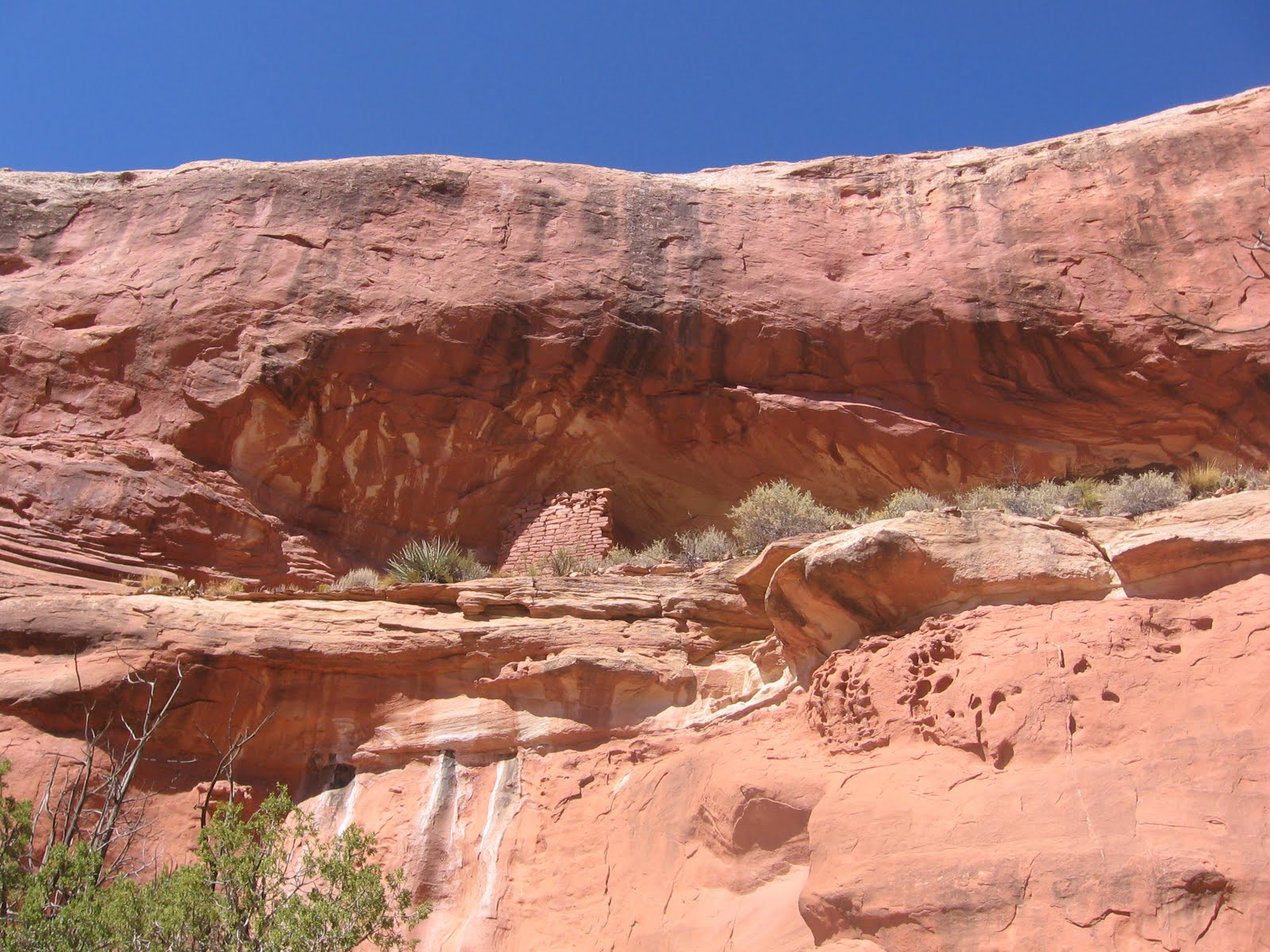
At the upper end of the side canyon I descended down the rocky wash and returned to the bottom. Scanning again with binoculars I saw a wall section under a rocky overhang nearly all the way to the rim. So I had to climb up a second time.

The wall fragment is hidden by trees and boulders and is visible only from the right angle, but the rock overhand covering the site is clear from many angles. I could only see an entrance into this protected site from the left side. There is a small fragment to the left of the remaining wall, suggesting that the whole open front was once walled in.

I slithered along the front of the site avoiding the steep drop off to look at the right side. On the right side there is a dry wall perimeter structure that is standing up well. I saw a corn cob along the way.

Further to the right there are two smaller wall fragments in small alcoves. I didn’t see a way to exit from the right side and had to return the way I came back to the left side of the site. This was the only site I saw in this area, but they are often hidden and easy to miss. At the canyon bottom near the side canyon junction there is a rubble pile that may be a site but it wasn’t very definite.

I spent about 3:30 hours hiking and climbing to find this site though the distance was only about 2 miles. The return hike took 1:15 hours for a total hike of 4:45 hours for about 4 miles. It was a 65 F degree mid October day and I carried 3 liters of water. There are many more locations to explore in this area, both up and down Cross Canyon.


I thought it odd at the time, but there are initials “JW” inscribed on the back wall of this site. This is a remote, hard to find site so why would there be graffiti here? After viewing a similar “JW” on the right end the well known Spruce Tree House ruin at Mesa Verde, it occurred to me that JW could be John Wetherill, one of the famous Wetherills that were instrumental in the development of Mesa Verde and other Four Corners ruins sites as places of major interest.

So John Wetherill may have visited this otherwise obscure site and left an historic inscription. Besides exploring the Cahone Trail, John Wetherill established trading posts in southeast Utah and led expeditions into the backcountry near Navajo National Monument, Monument Valley and Rainbow Bridge National Monument. I didn’t see a year carved here but one could guess around 1890.


Sunday, October 4, 2009

Mouth of Sand Canyon Trail

The Sand Canyon Trail in Canyons of the Ancients National Monument, in southwest Colorado, runs 6.5 miles north and south on the west side of Sand Canyon and passes many small Ancestral Pueblo Ruins sites.

About 3.3 miles up the trail there is a side trail to the east side of Sand Canyon that leads to several more sites. One of these sites is in a side canyon that is back toward the south end of Sand Canyon near the canyon mouth. (In 2011, this area off the Sand Canyon Trail might be considered closed.)

On this hike I was looking for a route across Sand Canyon that was closer to the south trail head. The south trail head is 12 miles west of Cortez along County Road G. From the south trail head I hiked about 0.5 miles to the end of the first spur trail on the west side. There is a distinctive rock formation at this point.
From there I hiked east for another 0.5 miles through the Pinon Pine and Utah Juniper forest to the edge of Sand Canyon. From the canyon rim the ruins site I was heading for is visible in the side canyon on the east side. At the view point the canyon is very steep and deep.
Back to the south a short distance there is a side canyon on the west side that offers a possible route into the main canyon. This side canyon has its own side canyon on the north and I was able to find a way there down to the bottom. Near the bottom I spotted a rebar stake that looks like something the archaeologists install to mark a site. There was a south facing alcove in the vicinity but I didn’t see any obvious ruins.

Once reaching the side canyon bottom the walking is fairly easy toward the main canyon. In the main Sand Canyon there is a vague horse trail leading up the canyon. At first, from above and below it is hard to see how anyone entered this site. It is a total hike of about 1.5 miles to get to the point below the ruins site.

After viewing the site from below, I looked to see if the East Sand Canyon area could be reached by climbing out of this side canyon. It is possible to climb to the east canyon rim area going up the east side canyon. The route requires a little scrambling but is not too bad. I climbed up the south side of the canyon before reaching the canyon head. From above, I could see the ledge that offers a route toward the alcove. It looks like there is a section just before the alcove that might be treacherous.

It also looks like there is a ramp leading to the rim from the ledge. On a later hike, I walked up the ledge and was able to enter the ruin. There is a notch that allows climbing into the site. I looked at the ramp and it looked too risky for one person to try alone. Perhaps two persons together could help each other up.

Looking back at the alcove from up the canyon I had noticed a wall fragment above it and to the left. I don’t think this wall section is visible from the west side angle. It looks like a castle rock type of site is above.

On the later hike I climbed out of the canyon on the north side near the canyon head and was able to get closer to this site. The wall section appears to be part of an isolated lookout tower. I didn’t see any other structures up on top. It is possible to climb in or out of the east side canyon on either the north or south sides, but there isn’t a marked route.

From this area it is about 0.25 miles east to the drill hole service road and the vicinity of the sites near and east of the Mad Dog Tower site. I returned to the main trail head using the 1.5 mile drill road route, but this road passes through a short section of private property.

My total first hike was about 3 miles and took 3:00 hours on a 70 F degree early October day. The revisit hike was on a 50 F degree day in late November and I spent some time getting closer to these two sites.


Friday, September 25, 2009

Mad Dog Tower Trail

The Mad Dog Tower is in the Sand Canyon area of Canyons of the Ancients National Monument in southwest Colorado. It is vaguely visible east of the Saddle Horn Ruin along the 6.5 mile Sand Canyon Trail about 1 mile north from the South Trail Head.


I started my hike at the South Trail Head and walked about 3.3 miles north past the last of the 10 or so small ruins sites in the lower part of the canyon. As the trail passes a small sign that says “Sand Canyon”, an unmarked side trail that I call the East Sand Canyon Trail turns back south on the east side of the canyon. The East Sand Canyon Trail passes by three side canyons that have at least seven more small ruins sites. (In 2011, this side trail off the Sand Canyon Trail is considered closed.)

The East Sand Canyon Trail exits at the head of the third side canyon and connects to the drill hole service road. The Mad Dog Tower is very close to the east side of the road. I walked right past it when I hiked in this area before, but it can be seen from the road. Excavation work on this site found a room block, an earth walled kiva with a tunnel and a trash pile midden, but these features aren’t visible on the surface.

I saw a story that the students working on the site were chased by dogs as they traveled to the site every day and named the site Mad Dog in honor of these dogs. It took me 1:30 hours to cover the 3.3 miles to the beginning of the East Sand Canyon Trail and another 1:00 hour to arrive at the Mad Dog site. I didn’t stop to view any of the other sites along the way on this hike.

While in this area I explored the alcove areas to the east of Mad Dog. The first area to the east had a small alcove to the left, a larger one in the middle and another large on the right. I could see a small wall section in the smallest of the three possible locations.

There is a hikeable route along the left near the sandstone wall. The interior of the small opening appeared to be covered with soot. The other two alcoves in this area appeared to be empty.

Further east there are some odd pipes approaching from the south that shoot right up to the top of the mesa. These are probably associated with the gas plant that is east of the trail head area. It looks like horse riders use the pipeline route as a trail. There are one or two small sites in the area to the right of the pipelines.

A rough trail leads from the pipes across this rubble strewn area toward the small wall section on the left side of the formation. There is another small wall fragment directly across on the right. This site is about 0.5 miles east of the Mad Dog Tower. I turned around here and followed a two track road that connects back to the drill hole service road at a point a few hundred yards south of the Mad Dog Tower. There are more alcoves and possible ruins sites to the east of where I stopped.

I followed the drill hole road back to the connection with County Road G that is 0.5 miles east of the trail head parking, slipping through a section of private property. There is a locked gate along the drill hole road that prevents motorized access to this area of Canyons of the Ancients. After the 2:30 hours to arrive at Mad Dog I spent 1:00 hour exploring to the east and the return hike took 1:00 hour. My total hike was 4:30 hours on a 70 F degree day in late September. I carried two liters of water.


Saturday, September 12, 2009

Saddle Horn Ruin Neighbors

Saddle Horn Ruin is one of the small Ancestral Pueblo Ruins sites on the Sand Canyon Trail in Canyons of the Ancients National Monument in southwest Colorado. There are at least two off the trail ruins sites that can be viewed from a distance in the vicinity of Saddle Horn. (In 2011 the off trail areas are considered to be closed.)

The south trail head for the 6.5 mile Sand Canyon Trail is 12 miles west of Cortez, CO on County Road G. The Saddle Horn Ruin is about 1 mile north along the well marked trail. Turning off the trail and going east and slightly north for a about a quarter of a mile to the rim of Sand Canyon. I scanned with binoculars across to the other side looking for a tower site known as Mad Dog Tower.

I didn’t see anything from the rim but moving back to a higher spot and repeating my scan several times I finally spotted the elusive tower. It is visible in line with the right side of the large rocky outcrop that is in the middle of this view. It appears to be only about a half mile away but Sand Canyon is very deep and steep and in the way. (I think the Mad Dog Tower can be sighted from the Saddle Horn ruins without leaving the Sand Canyon Trail.)

There is an unmarked East Sand Canyon Trail that accesses the area of Mad Dog Tower. Follow the Sand Canyon Trail north for about 3.3 miles to the point where there is a small sign that says “Sand Canyon.” The main trail continues north, but there is also a trail that crosses and turns south toward the side canyons on the east side.

On this hike I tried walking south along the west rim of Sand Canyon to see if there was a shorter route over to the east side. There is a service road for drill holes on the east side but it passes through private property.

I walked to a point that is about 0.7 miles east of the Castle Rock Pueblo and overlooking the beginning of the drill hole service road.  Looking back north up the canyon I spotted an alcove ruins site that looks like it is in a very inaccessible position. This site is in a short eastern side canyon near the junction of Sand Canyon with McElmo Canyon. There are cliffs both above and below the site and there isn’t any apparent entry point.

I thought this would be a rarely viewed site but I caught a glimpse of it as I drove past the canyon mouth on County Road G. From the view point it was about 0.5 miles across country back to the Sand Canyon main trail and then 0.5 miles back to the trail head. My hike was about 3:00 hours for 3 miles, with much of the time spent scanning for these elusive sites.


Tuesday, August 25, 2009

Woods Canyon Pueblo Trail

The south leg of the Woods Canyon Trail leads to the large Woods Canyon Pueblo in Canyons of the Ancients National Monument in southwest Colorado.

 The trail head is on County Road U west of County Road 15 across the road from one of the Carbon Dioxide gas plants. This area is near the town of Yellow Jacket, CO and west of Highway 491.

The trail follows an old road down into a side canyon and then into the main Woods Canyon to a junction that allows travel north and south. For this hike I turned south toward and then under the major power lines that cross the canyon a short distance to the south. From the trail junction there is also a large Ancestral Pueblo ruins site about 1 mile to the north.

A few hundred yards past the power lines some cliffs become visible on the west side. With binoculars, some wall sections of a ruins site are visible just below the canyon rim. There is a creek with flowing water between the trail and the ruins site. Parts of the creek bottom are very thick with vegetation.

I continued on the trail a little south of the ruins site until I found an area where the vegetation thinned out and the creek could be easily crossed. I didn’t see a trail going up to the ruins site. A short distance up the canyon side, rubble pile ruins structures start to appear and there are many of them.

The climb up to the standing wall sections is steep and a little treacherous. From below, some wall sections on the canyon rim are visible but I couldn’t see them from the ledge just below the rim. I didn’t see any easy way to get onto the rim from the ledge. (On a later hike I found a route that connects to the trail along the ledge under the rim.)

Besides the most obvious below the rim wall sections, there are others visible along the rim to the south and maybe some storage sites to the north.
From the elevated position there are views up and down Woods Canyon. Several of the large boulders to the south show rubble remains on top and there are many rubble mounds down the canyon side hidden by the Pinon Pine and Juniper forest.

The Woods Canyon Creek appears to have year round water and some of the pools support cattails and bulrush. I saw at least one large cottonwood tree in the canyon bottom. There are also fields of sagebrush visible, indicating good soils for farming. Woods Canyon appears to be a relatively lush location that could have supported large villages.


I returned after visiting this site, but the trail appears to continue further south. My return hike to the trail head from the ruins just below the rim took about 1:00 hour for a distance of about 2 miles.

I spent 4:00 hours total on this hike but much of it was spent exploring the side canyon west of the trail junction. That side canyon looked promising but I didn’t find anything but good views. I carried 2 liters of water on a 70 degree F partly cloudy day in late August.