Wednesday, November 16, 2011

Woods Canyon East Rim Road-North

The Woods Canyon area of Canyons of the Ancients is west of the community of Yellow Jacket in southwest Colorado. From Highway 491, turn west on Road Y and south on Road 15.

About 0.2 miles south of the junction of Roads U and 14, a well maintained gravel road turns west and leads south for 6 miles along the east rim of Woods Canyon, eventually reaching an overlook point of the junction of Sandstone Canyon and Yellowjacket Canyon.

About 1.6 miles along this road, there is an unmaintained side road that runs parallel to the main road on the east side for about 1 mile. I started my hike at the north end of this side road and walked this segment without noticing any Ancestral Pueblo ruins sites.

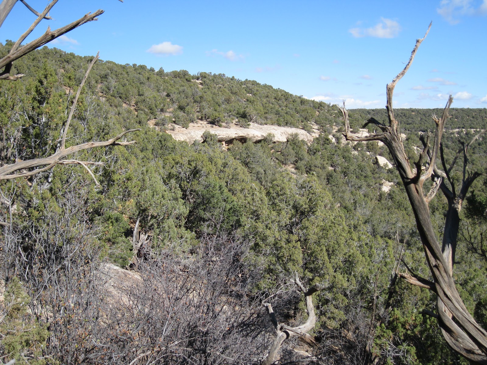
There are several points where the road is close to the rim and allows some good views to the east. From the south end of the segment I turned east to find the canyon rim again. From this angle there are some alcoves visible in the second level of cliffs.

The alcoves are approachable, without a trail, from the south side. There aren’t very many alcove ruins sites in the Canyons of the Ancients. This is one of the bigger alcove sites that I have seen here.

There are a series of these small structures in the alcoves at the base of these cliffs. Rubble flows away from the alcoves down the slope.


These rooms all seem to be small. I didn’t notice any pottery shards or rock art around this site.

Below the alcoves, there are some large boulders. Often, large boulders form the foundation of ruins sites. In this case, there is a large rubble pile site near the boulders that doesn’t use the boulders as part of the structure.

The amount of stones used for this rubble pile site is probably greater than the entire alcove collection put together. Alcove sites are popular to visit as they are usually better preserved, but the rubble pile sites usually seem to be much larger and are more numerous in the Canyons of the Ancients.

I found a small gap in the cliffs to climb back to the rim, but this spot isn’t obvious and would be a tricky descent. The cliffs extend for a distance to the north, so the south side approach appears to be the easiest. From above, the rubble pile ruins site is visible. I didn’t see any rim top structures above the alcoves.

My total hike took about 2:00 hours for 2 miles on a 48 F degree mid November day. There is a mesa top ruins site along another side road about 1 mile south of this site. Both of these sites are close to the large Wood Canyon Pueblo site.

Wednesday, November 2, 2011

Mockingbird Mesa West Rim

The Mockingbird Mesa area in the Canyons of the Ancients is 8.5 miles south on County Road 12 from the junction with County Road BB, west of Pleasant View in southwest Colorado. The route zig zags and the road numbers change before arriving at the normally closed gate near a carbon dioxide gas plant.

Starting out to the south parallel to the main road, there is a cleared swath of Pinon and Juniper forest that leads about 0.5 miles to a rubble pile Ancestral Pueblo ruins site. Keep an eye out for it along the west edge of the cleared area. The site is not visible from the main road.

This site and another similar site that is on the east side behind the carbon dioxide plant are the easiest to find and visit in the north part of the Mockingbird Mesa area. From this site, I hiked directly west a short distance to the mesa top rim that overlooks Negro Canyon.

I arrived at the head of a side canyon. Scanning with binoculars, there is a rubble pile visible on the north side of the side canyon near the point. It took me a total of 0:45 minutes to arrive at the site.

 The first structure visible on the east side of the site looks like a square tower. A wall segment on one side is still standing with the outline of an adjacent side.

A lot of rubble has collapsed into the interior of the room and some is flowing down the slope.

Further along there is a small alcove that appears to be the center of the site. The thick roof of the alcove acts as a foundation as well as a roof. Inside the alcove there are some small preserved wall sections. Like many Canyons of the Ancients sites, this village is partly on the canyon rim and partly just below the rim.


The view from the site is toward the south along the west rim of Mockingbird Mesa. There is some private property on the floor of Negro Canyon. Scanning from here, I didn’t notice any more ruins sites.

I returned back along the rim and continued south to the second side canyon. The terrain on the second side canyon seemed similar but I didn’t notice any more sites. The second side canyon has an old road trail that crosses the floor and climbs the south side.

I considered descending and crossing below but decided to stay along the rim. On the south side the trail that crosses can be found connecting to the main road. This junction is just south of a cattle guard and a barbed wire fence, about 2 miles south of the gas plant. A short distance from the main road, this trail has a side trail that continues southwest.

I followed the southwest leading trail for 0:45 minutes through the forest until it arrived at a third long side canyon that angles back to the northeast. I looked along the rim of this side canyon for about 1:00 hour but didn’t notice any ruins sites.

Following along the rim led back toward the main road. This part of the hike between the second and third side canyons turned out to be a loop. The return hike along the main road took about 0:45 minutes. My total hike took 5:25 hours for 9 miles. I carried and drank 3 liters of water on a 60 F degree late October day.

Saturday, October 22, 2011

Cross Canyon Trail-Lower

The lower Cross Canyon access road is a west turn 5.9 miles south of the turnoff to the Painted Hand Pueblo site along paved County Road 10, along the Utah and southwest Colorado border. The access road is marked as San Juan County 2031 and descends somewhat steeply for 2.3 miles down into Cross Canyon.

At the bottom there is a creek crossing. Just west past the creek there is a right turn that enters Cross Canyon and heads toward McLean Basin and the Cross Canyon Wilderness Study Area.

After 3.2 miles there is another crossing of the same creek. I started hiking at the crossing but the road is drivable for another mile to a sign marking the San Juan Resource Area where there is room for parking. Past the sign, the road becomes rougher.

After 0:15 minutes of hiking past the sign, the road veers away from the flowing creek while a trail that is marked as closed to vehicles continues north following the creek up Cross Canyon. Except for the no vehicles sign, the trail isn’t marked. This trail seems to weave back and forth across the Utah and Colorado border for a while before settling into the Canyons of the Ancients Monument area in Colorado.

There is a creek crossing at the trail starting point and many more crossings as the stream meanders across the canyon bottom area. The crossings during mid October were 6 to 10 inches deep and usually only 6 to 8 feet across. In some cases there are some rock stepping stones, but my feet got wet with every crossing.

The canyon bottom area has a lot of sagebrush, greasewood, and three wing saltbush with cottonwoods and tamarisks close to the creek. Sometimes the trail pushed through dense patches tamarisk. The canyon sides were steep with Pinon Pine and Juniper in the segment I walked. I scanned the canyon rims with binoculars frequently but didn’t notice any ruins sites up above.

About 1:00 hour of hiking past the San Juan Resources sign, there is a large boulder based Ancestral Pueblo ruins site that sits in the middle of the canyon. Rubble from the site flows down the steep slopes below the rocky outcrop.

Some of the wall sections have held together on top. There are good views up and down the canyon from the boulder tops. To the east, it looks like there might be an old trail that starts to descend part of the way down from the canyon rim.

Most of the pottery shards I saw were on top. Mostly I saw plain white pieces with a few corrugated and a few painted designs.

On the south side below the top, there is a rock overhang with walls still intact. This large castle rock type site was the only one I noticed in the first 1:20 hours of hiking.


About 0.3 miles north of the castle rock ruins I thought I had found a tower, but it appears to be a historic ranching type ruins. There is a piece of metal bed hanging on the wall and other ranching artifacts lying among the rubble. There is some cement plaster helping to hold the walls together.

About 0:30 minutes of hiking further, as the creek makes a turn to the east, there is a petroglyph panel in an alcove a short climb above the trail. The horse images must mean that at least some of this is the work of the Utes.

Below the petroglyphs there are two rock walls forming a set of level terraces. These level spots have a good view of the creek below and look like a good place to relax. I turned around here about 3:00 hours into my hike. My return hike without any stops took 2:00 hours. My total hike was 5:00 hours for about 9 miles. I hiked on a 65 F sunny mid October day and carried 3 liters of water.


18407_$5 Shipping on Orders of $99 or More!

Friday, October 14, 2011

Squaw Point near Lower Cross Canyon

The Cross Canyon access road is 2.7 miles northeast of the turnoff to the headquarters of Hovenweep National Monument along paved County Road 10, along the Utah and southwest Colorado border. The access road is marked as San Juan County 2031 and turns west descending steeply for 2.3 miles down into Cross Canyon.

At the bottom there is a creek crossing. Just past the creek there is a right turn that enters Cross Canyon and heads toward McLean Basin and the Cross Canyon Wilderness Study Area. The trail I followed is about 1.2 miles up this road on the left. It is clearly visible while descending into the canyon. This rough uphill road connects to other roads on top of Squaw Point. This area is slightly outside the official Canyons of the Ancients, but still BLM managed land.
I’ve started up this trail before but turned back about halfway up due to biting gnats. Continuing to the mesa top, there is a side road that turns south. I followed this route to the end of the trail. After about 1:00 hour of hiking the trail ends and a large boulder based ruins site is visible further south. It took me another 0:20 minutes to arrive at the site. There are two short side canyons between the end of the trail and the ridge location of the boulder ruins.
There is a lot of rubble on the top of the boulder, but only fragments have held together as walls. This site has one of the most dramatic of locations. It is on the point that overlooks the very broad junction of Cross Canyon and Squaw Canyon. The rocky point location is visible from miles around but it is not obviously a ruins site from a long distance view.

Most of the interesting features are along the east side. There are two small sections of wall structures that have been sheltered with some brick fragments visible above.

Further on there is a kiva depression with some wall brickwork visible. There were many pottery shards around the kiva.
The largest and most conspicuous pottery shards were white with black smudges. This style seemed unusual. There were also corrugated and a few painted designs.

Further on there is a large circular rubble pile. The sides of the boulders are tall and very vertical and I didn’t notice any easy way for the residents to climb to the top.

I noticed three petroglyph panels. One of them had some very clear and interesting images. There is a good image of a hunter with a bow and arrow aiming at a mountain sheep.

On the left side of the same panel are two reclining figures, one playing a flute. I can’t tell what the other figure is doing. The pair seems to be enclosed in a frame.


Looking back north along the east rim of Squaw Canyon, I think another boulder based site with wide views is visible two or three miles away. The Squaw Point road leads close to that site. It is interesting that these two sites have a very clear line of sight. My return hike took 1:10 hours and the total hike was 3:15 hours for about 5 miles. I carried and drank 2 liters of water on a sunny 68 F degree mid October day. The sunny mild days of fall are probably the best time of year for hiking in the Canyons of the Ancients.

Saturday, October 1, 2011

Hovenweep Canyon near Mockingbird Mesa

The route to Mockingbird Mesa in the Canyons of the Ancients is to follow County Road 12 south from the junction with County Road BB for 7.2 miles and make a left turn at a BLM road junction. This area is west of Pleasant View, in southwest Colorado.

Staying to the right at the Mockingbird junction and right at the next junction for 1.2 miles leads to a south leading dirt road trail that provides an access to the east rim of the upper part of Hovenweep Canyon. There is a carbon dioxide plant visible 0.3 miles past where I started hiking.

The unmarked dirt road trail leads about 2 miles southwest and then is blocked by a gate at private property. Near the end of the road, a carbon dioxide pipeline crosses the road and provides a cleared route down into and across Hovenweep Canyon.

Hiking along the road, I didn’t notice any Ancestral Pueblo ruins sites. Scanning up and down the canyon, I thought I saw a rubble pile and a wall with a doorway about one mile back to the north. I didn’t follow the pipeline down into the canyon, but instead hiked back north and found a gentle slope leading down.

The canyon bottom here is a side canyon to the east of the main Hovenweep Canyon. The Cottonwood trees along the dry wash made me think that there might be a ruins site in this canyon bottom area. Even though there wasn’t any flowing water here, there must be some not far below the surface.

I’m surprised by how often I stumble into ruins sites without any hint that they are here. This large site is completely obscured by thick Pinon and Juniper forest and isn’t visible from more than 50 feet away. This isn’t the site I saw from the canyon rim. The rubble piles at this site are tall and cover a large area but are overgrown and it is hard to view the overall site.

I didn’t see any walls that have held together. The good news is that the site is marked by the Cottonwood trees growing along the small drainage that joins the main drainage from the west. The L shaped pattern of the Cottonwood growth along the watershed is easy to spot from high angle views. I was about 2:00 hours into my hike when I arrived at this hidden site.


I continued north, climbing up a slope to a mesa top area. I didn’t see the ruins sites I was looking for on the way up, but I saw many pieces of pottery. At the rim I scanned around and spotted some rubble. Close to the rim, there is a circle of large stones and below was the wall and doorway that I had spotted from a mile away.

This wall and the circle above are supported on massive slabs of stone that have separated from the main cliffs. From this unusual large stone structure I couldn’t see anything else, but the rubble pile I had spotted from the distance was lower and slightly to the east.

The rubble pile could have been this large boulder based site. There are other small structures around the base of this large boulder.

I was stunned to find that there are two boulder based sites nearly side by side. This must have been an impressive place when these twin structures were standing tall. Both of these boulders have small wall sections still holding together toward the back of each.

Behind the east boulder, there is a wall constructed between two boulders. The upstream side of the wall has filled in with sediment such that you can stand at the level of the top of the wall. I wondered if this was a device to catch water flowing through the site and save it in a cistern.

The pottery shards I saw were mostly corrugated. There were only a few painted visible along with some smooth gray pieces.

For the return hike I walked the short distance west to the east rim of Hovenweep Canyon and followed the northeast leading rim back to the carbon dioxide plant. Close to the plant in a small drainage, I saw what I think is a check dam. I didn’t notice anything near the check dam but I was at the end of my hike. My return hike took 1:00 hour of slow walking.

My total hike took 4:30 hours for about 5 miles. On a late September day I carried and drank 3 liters of water. It was about 65 F degrees at 9:30 AM and 83 F degrees at 2:00 PM.