Monday, June 30, 2008

Sand Canyon Pueblo Trail

The Sand Canyon Pueblo Trail in Canyon of the Ancients National Monument in southwest Colorado is a short interpretive trail to a large mostly unexcavated Ancestral Pueblo site. It is located at the north trailhead of the 6.5 mile Sand Canyon Trail.

The village is U shaped around a spring at the head of Sand Canyon. The trail has two arms, to each side of the village. The overall site is one of dozens in the area and had about 420 rooms, 100 kivas, and 14 towers. Most of what is visible now though is piles of rubble. Several hundred people are thought to have lived here between 1245 and 1290 AD.


The west arm of the trail circles around the outer wall and then passes through to the interior. The west side is thought to have the most kivas and open spaces and may have had a different role than the east side of the village.
 The terrain along the trail is fairly thick Pinyon Pine and Utah Juniper forest with a lot of sage brush and yucca plants. The forest has grown up through many of the collapsed structures.

There are good interpretive signs along the trail explaining the layout of the village. The signs include drawings that show how the structures are thought to have looked. These are helpful as you can't tell much from what appears now.
There are spots on each side of the canyon with views down the canyon to the south. The east side gives a good view back to the village on the west. Down the canyon there are quite a few small structures tucked up under rock alcoves. These are visible on the Sand Canyon Trail.

There is about a mile worth of hiking on this trail. The time spent here depends on how long you want to linger.

This is a tricky trail head to find. It is on County Road N west of County Road 16. Turn west off of Highway 491 onto County Road P north of Cortez and zig zag west and south.


Tuesday, June 24, 2008

Yucca House National Monument

Yucca House National Monument, just south of Cortez in southwest Colorado, is an unexcavated Ancestral Pueblo site in the valley between Mesa Verde in the east and Sleeping Ute Mountain in the west.


This must be one of the most obscure National Monuments in the National Park System, despite having been added to the system in December 1919 following the donation of the land by the original owner Henry Van Kleek. There are no signs along the highways to alert visitors and the route into the site is not even a public road. Going there is like visiting a red roofed ranch site that had a large ruin site in the south forty.


Yucca House was first described in 1877 and was the largest ruins site to have been located up to that time. The setting was adjacent to good agricultural land that is today irrigated hay fields. There are seep springs on the site that provided water. The site is also very scenic, with views of Mesa Verde and Sleeping Ute Mountain nearby and the LaPlata and San Miguel ranges visible in the distance.


The only section of wall that is intact is part of what is called the "Lower House". It is one of two conspicuous mounds on the site. We usually see these sites after they have been excavated and fixed up somewhat. This wall was stabilized in 1964. Very little other work has been done on this site. This site is an example of what nature will do to the works of man after we leave.


In an otherwise dry area there are conspicuous green spots showing the location of seep springs that provided water for the site. The vegetation that over runs the site is mostly sagebrush, cactus, and greasewood. This isn't a very comfortable site to hike across. I didn't see any Yucca plants at Yucca House. The name comes from nearby Sleeping Ute Mountain which in the Ute language was called "mountain full of Yucca".

The "Upper House" is the major mound on the site, standing 15 to 20 feet above its foundations. When looking at these filled in rubble piles I wonder how one would even start to unravel the story here.

I wandered about the site for about 1:20, longer than the average that appeared on the sign in log. Yucca House is not so difficult to find if you have the directions. Turn west on County Road B about five miles south of Cortez off of Highway 491. Turn right or north after 0.8 miles on a gravel road and follow this twisty route through the hay fields for 1.4 miles until you are in the yard with two red roofed ranch houses. It seems odd but that's it.


Wednesday, March 5, 2008

Holly Ruins Trail at Hovenweep

The Holly Trail is a 4 mile route from the Hovenweep National Monument campground to the Holly Ruins Group. There is a north access about 5 miles north of the Visitor Center on County Road 10, then about 1 mile along a rough road. The Horseshoe and Hackberry Trail is along the same side road.

At the north trail head, the main trail travels along the west rim of the canyon, but there is an unmarked trail on the east side that provides some different views.

Starting at the north end of the trail one of the most impressive ruins is Boulder House, perched on a large sandstone boulder in the bottom of Keeley Canyon. It was apparently built from the inside, rather than using scaffolding on the exterior.
Just past Boulder House is another large structure sitting on the rim rather than on a boulder. The trail guide doesn't mention a name for this large building. Sleeping Ute Mountain is visible in the distance.
Several of the other ruins here seem to also be perched on boulders in the canyon rather than use the canyon rim. Extensive rubble piles spill down into the canyon.

Just past the Holly Ruins Group there is a short side trail leading to what is thought to be a Solstice Panel. There is a natural rock portal that allows a beam of morning sunlight to strike a series of petroglyphs.

Past the Holly Group of ruins the trail continues along the rim of the canyon and then descends to the bottom, cutting through a narrow gap in the rim rock. The trail in the creek bed below didn't seem very interesting to me. The terrain changed from Pinon Pine and Juniper forest to a sagebrush area and there are signs that cows graze in the area.


There was one collapsed ruin along the banks of the dry wash. This seemed to be an unusual location as most of the other ruins were located on the rim or on big boulders.

At the south end of the trail there is another narrow crack to squeeze through climbing back to the rim. The trail arrives in the park campground, then connects to the Little Ruin Canyon Trail at park headquarters.

Hackberry Ruins Trail at Hovenweep

The Hackberry Trail in Hovenweep National Monument along the southern Utah and Colorado border is a the second part of 1.0 mile round trip to two ruins groups, the Horseshoe Group and the Hackberry Group.

The Hackberry and Horseshoe Trail Head is about five miles north of the Park Headquarters at Hovenweep along paved Road 10, then down a primitive dirt road. The turn off is marked with a small bird symbol rather than a sign.

The Holly Ruins Group is another 0.8 mile down the same dirt road. The first view of the standing structures of the Hackberry Group is from a short spur trail that views across the canyon. There are rubble remains on both sides of the canyon.

The Hackberry site is a large site with many collapsed rubble pile structures. It is thought to have been one of the largest populations in the Hovenweep area due to the reliable water supply in the canyon.

The stone work in this area uses small pieces inserted between the larger bricks. Some places where this style is used are referred to as being Chaco Canyon culture influenced, though the interpretive information at this site doesn't say that. All of there sites were abandoned by about 1300 AD.

Moving around to the east side of the site, an alcove is visible below the rim with a small structure inside. The way down into the canyon is closed, so it can only be observed from the rim.

From this angle, the Hackberry trees growing in the relatively moist canyon bottom can be viewed. The rim environment is Pinon Pine and Utah Juniper with patches of Sage Brush, Mormon Tea and Prickly Pear Cactus.

Cajon Ruins Trail at Hovenweep

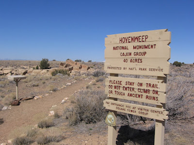
The Cajon Ruins Trail is an outlying site in Hovenweep National Monument. It's the trickiest of the outlying sites to find, as there isn't a sign to help you, only some cryptic symbols.

The Cajon Ruins site is a few miles south of the main park site. It is inside 40 acre fenced area just inside the boundary of the Navajo Indian Reservation deep in the southeast corner of Utah. The trail is very short, leading to a small group of pueblo ruins perched on the edge of the small Cajon canyon.

The terrain is dry and nearly treeless sagebrush country. There is a seep of water at the bottom of the canyon that made this site livable. To the southwest the spires of Monument Valley are vaguely visible.

The Hovenweep sites are known for their diversity of masonry designs, using squares, rectangles, ovals and D shapes. The people that lived here grew corn, beans, and squash. They are thought to have abandoned the area in the late 1200s and moved further south.

There isn't much of a hike here, more of a stroll to observe the ruins. Within the 40 acre fenced area there is room to wander around and view the surrounding mountains. There aren't any trees here to obscure the views.