Wednesday, August 25, 2010

Burro Canyon Southwest Trail

The lower and southwest end of the Burro Canyon area, in Canyons of the Ancients in southwest Colorado, can be explored along an old road that descends from the south rim and crosses to the mesa top area between the two apparent parallel canyons.

The old road curves back to the west and runs along the south side of a large sky island, then continues out to viewpoints overlooking Yellow Jacket Canyon. There aren’t many official trails in Canyons of the Ancients, but the old roads often make good routes through these wild canyons.

The unmarked old road is about 4.8 miles west of the Canyons of the Ancients entrance sign on the west extension of County Road N. This entrance sign is 1.2 miles west of the north trail head for popular Sand Canyon Trail. The trail makes long switchbacks for about 1.5 miles down to the bottom of Burro Canyon.

It then follows the canyon bottom east for about 1 mile before climbing out to the mesa top. Looking across, there are several grassy areas on the mesa top area near the sky island. About half way down, another trail splits off, heading west down canyon. At the canyon bottom, the trail passes a very large pour off point.
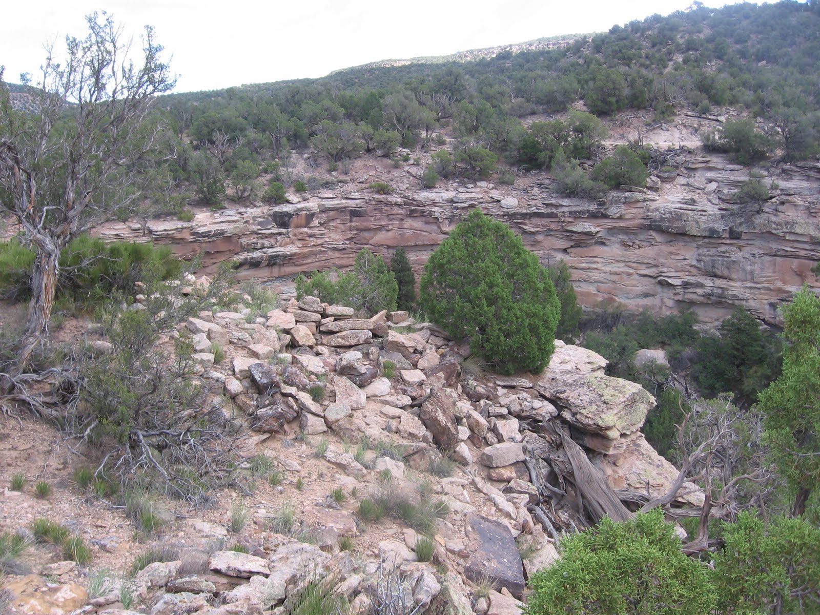

There is a small Ancestral Pueblo ruin site perched on the rim overlooking the pour off. The site can be viewed from the trail and it is only a short hike to get a closer view.

This small site looks like it might have been a circular tower. I didn’t see any other structures associated with this site. My hike continued up canyon and onto the mesa top, and out to the point overlooking Yellow jacket Canyon. Despite the scenic canyon country and some reasonable looking locations, I didn’t see any more ruins sites in this area.

Hikers interested mostly in ruins sites could stop at the canyon bottom and return to the rim. There are several ruins sites to find at the upper end of Burro Canyon, so I was disappointed not to find more in the lower end.
It took another 1:50 hours of hiking to get to a point, west of the sky island, where there are views in both directions of Yellow Jacket Canyon. The Yellow Jacket Canyon bottom view down canyon has some roads and farming activity and is mostly private property. The trail continues further than I went, at least another 0.5 miles out to a point more in the middle of Yellow Jacket Canyon.

The view up canyon has some sandstone outcrops that I scanned, looking for the Yellow Jacket pictograph panel. I think this panel is in this area, but I couldn’t see it from this distance. My total hike was 6:40 hours for at least 8 miles on an 80 F degree late August day. I carried 3 liters of water and drank every drop.

On a separate hike in late September, I started at the same rough road but then followed the road that splits off half way to the canyon bottom. This trail follows the south rim west and curls around a point that overlooks Yellow Jacket Canyon. There are good views toward the mouth of Burro Canyon and across Yellow Jacket Canyon.

It might be possible to hike all the way to the bottom of Yellow Jacket Canyon here, but I didn’t see any ruins sites below to head for. A segment of the canyon bottom in this area is public land, but crossing and trying to climb the opposite side looks like a major effort.
The trail curls around the point and follows a long section of southwest facing cliffs. I thought this segment had some potential ruins locations, but I didn’t notice any despite a lot of scanning. I turned around at the end of the cliff segment, about 3.5 miles from where I started. The trail continues south at this point and may eventually loop back north toward the starting point, but it could be a long distance. The end of this loop is the road that is directly across the road from where I started, so a separate hike could start there. This separate hike took 4:10 hours for about 7 miles on a 78 F degree late September day.

 
Enhanced by Zemanta

Tuesday, August 10, 2010

Negro Canyon West Rim Trail from Painted Hand

Negro Canyon is to the east of Hovenweep Canyon and west of Sandstone Canyon in the Canyons of the Ancients National Monument in southwest Colorado. The upper trailhead for the Hovenweep Cutthroat Castle Trail can be used as a starting point for a hike to the west rim of Negro Canyon. This area is about 10 miles north of the Hovenweep Visitor Center on County Road 10.

There is an old road that branches off near the Cutthroat Trail Head and descends into Hovenweep Canyon. As this road passes below the Painted Hand Pueblo site, there is a side road that climbs to the east rim of Hovenweep Canyon. This side road can be spotted easily from the rim area above, but is easy to miss down below if you’re not watching for it.


At the rim, the mining road continues south but I turned east off the trail and walked the short 100 yard distance to the west rim. It took 1:00 hour of hiking to get to the west rim of Negro Canyon.

Scanning the rim area to the north and south with binoculars I spotted an Ancestral Pueblo ruins site in the level area below the cliffs. In the area overlooking the site, there is a drainage that offers a way down, though it is tricky and there is an easier route about 200 yards to the south.

The site spotted from the rim looks like it is spread out on both sides of a drainage, or it could be considered to be two sites. The structure to the north has a large section of wall holding together on one side and looks like a large rubble pile on the other sides.


Just south across the small drainage there is a circular looking structure. Rubble piles form the circle and there is a depression in the middle. The amateur observer might think this resembles a great kiva. I didn't want to climb back to the rim the same way I came down and walked south where the cliffs appeared to be easier to climb. There were some alcove formations along the way, but I didn't see any signs that they had ever been used.
About 150 yards south I came across another rubble pile site. This site also appeared to be circular and appeared as rubble piles. This site is close to the base of the cliffs and the forest is thick enough that it is obscured unless you are very close to it. The cliffs are easier to climb in this vicinity than where I descended and I made my way back up to the rim.

The canyon rim makes a bend to the east above the second site and gives a good view back to the north. Scanning back north I saw a ruins wall section north of the first ruins site and decided to walk back, about 0.4 miles to look closer.

 Above the wall section there are some rubble remains of a rim site. This site is at the south junction point of a short side canyon off of the main canyon. Across Negro Canyon is Mockingbird Mesa and the large power lines to the industrial sites there are visible.


The wall section that I saw from the distance appears to be part of a circular tower that has a precarious perch over a steep cliff and is well below the rim top rubble remains. There is a notch in the cliff that might be a steep and narrow way down, but I didn't try it. It was hard to get a good angle to see the tower from the rim above. A juniper tree has taken root and perfectly blocks the view. Unfortunately, I didn't notice this structure when I was down below, only about 200 yards to the south.

There are some rough 4WD trails in the area below the tower. There is a road that enters the north end of Negro Canyon but there is a normally closed gate that blocks unauthorized vehicles, though a hiker or mountain bike can enter.


The view of the tower wasn't better from the south angle, but there is a good side view of the overall site. If a tower in this position was used for communication, there might be another to look for on the east side of Negro Canyon. I spent about 2:00 hours in the area of these three close together sites.

From a previous hike I know there is another boulder based site about 0.5 miles north of this area along this same rim. My return hike from the tower site took 1:10 hours for a total hike of 4:15 hours. The temperature at 9:30 AM was 70 F and it was 82 F at 1:45 PM on an early August day. I carried and drank 3 liters of water.


Wednesday, August 4, 2010

Cow Canyon West of Lowry Ruins

The large mesa top Lowry Ruins is one of the featured sites in Canyons of the Ancients National Monument in southwest Colorado. It sits on a hilltop between two forks of the head of Cow Canyon and is the center a large community of outlying sites.

Near the parking area a primitive road heads south and allows hikers to explore for some of the surrounding sites. Lowry Ruins is located 9 miles west of Pleasant View, CO on County Road CC.

I hiked south of Lowry Ruins along the primitive road for about 0.5 miles, and then turned west to the east rim of the Cow Canyon west fork. Scanning with binoculars, it looked like there was a nearby alcove site below a canyon rim and further on I could see a rubble pile in a higher layer of cliffs. The alcove site was a little vague but there was a rubble pile under the cover of a shallow rock covering.


The rubble pile site was a little tricky to find, even though it was clearly visible from a distance. From above it was hard to get a good angle to view it, and several trees have taken root right in the middle of the site. It took me 1:00 hour of scanning and hiking to arrive at this moderate sized site.


From below, it appeared to be based on a large boulder with a lot of rubble having slipped off and formed a pile down below. I spent about 1 hour exploring the area around these two ruins sites. After viewing these sites I hiked slowly south about 1 mile along the east rim of the west fork to the point that overlooks the junction of the two forks of Cow Canyon. I didn’t notice any ruins sites along the way to the point.


This junction had very steep cliffs and a good view down Cow Canyon. I thought that the jumble of rocks at the point looked like a good location for ruins site but all the sites in this area appear to be closer to the canyon bottom in the east fork, which seems to have better southern exposure and was closer to the water source. Continuing back north along the rim I saw three likely boulder based sites well below the rim, close to the creek at the bottom. The northern most of these three sites I had visited before. On this hike, I only viewed these sites from the rim.

My total hike took 4:40 hours for about 4 miles. I carried and drank 3 liters of water on a 75 F degree day that had higher humidity than is typical in this area.


Sunday, July 25, 2010

Mockingbird Mesa East-Sandstone Canyon West Rim

Sandstone Canyon is one of the Canyons of the Ancients, located to the east of Mockingbird Mesa and west of Pleasant View in southwest Colorado.

The hiking starting point is the normally closed gate next to the Carbon Dioxide processing plant 8.5 miles south along County Road 12 from County Road CC. Instead of hiking along the gravel road I stayed close to the canyon rim.

For first time hikers in the Mockingbird Mesa area, there is an Ancestral Pueblo ruins site directly behind the gas plant close to the Sandstone Canyon rim. There is another large rubble pile site about 0.5 miles south on the west side of the gravel road at the point where the road is very close to the canyon rim.

There are also at least two boulder based sites visible down in the canyon in the first 0.5 miles. I skipped past all of these, looking for more sites further south.

After 1:30 hours and about 2.2 miles I came across a small mesa top rubble pile site that was about 100 feet from the canyon rim. I noticed several pottery shards that had washed down that led me to the site. The hiking along the rim was level and easy with a vague deer trail to follow.

The views are good along the rim and I stopped frequently at good overlook points to scan the canyon bottom with binoculars. There are some possible ruins sites down in the canyon but I couldn’t tell for sure.

In another 0:30 minutes I arrived at a south facing point overlooking the area where water from Sandstone Canyon drains down toward Yellow Jacket Canyon. Below the south facing point there are two boulder based ruins sites very close to each other.

The eastern most site has a wall section holding together under the shelter of the boulder. There is a small amount of rubble on the top of the boulder. There are other large boulders nearby that could have been chosen as building sites, but weren’t and I didn’t see any structures on the canyon rim.

Hiking west back toward the rim, I came across another boulder based site only about 100 yards to the west. I was surprised that these two were so close together. The further west of the two sites is also mostly rubble with small wall sections still intact and seemed a little larger than the eastern site. There was rubble remains on two boulders at the west site. One of the two large boulders is very close to the rim but not attached to it.

These two boulder sites have a spectacular view south toward the Yellow Jacket Canyon area. There may be a large pictograph panel near this canyon junction. Getting down to the drainage below looks feasible but the cliffs look steep, so it’s not clear if this is a good route for finding the panel.
I started back along the east side of the long sagebrush field that is in the middle of Mockingbird Mesa. The gravel road is across on the west side of the sagebrush and the large power lines are visible. A rock outcrop on the east side of the sagebrush had a small but mysterious circle of stones.


My return hike took 1:30 hours and I finished the last 1.5 miles on the gravel road. My total hike took 4:30 hours for about 6 miles. The starting temperature in late July at 9:00 AM was about 70 F and it was about 88 F at 1:30 PM. I carried and drank 3 liters of water. The biting gnats that are a nuisance in these canyons in June are out of season by late July.


Saturday, July 3, 2010

Burro Canyon Northeast

Burro Canyon is tributary to Yellow Jacket Canyon from the east and is more or less in the center of the Canyons of the Ancients National Monument in southwest Colorado. The access is the west extension of County Road N, west of the north trail head for the popular Sand Canyon Trail. 

A short distance past the Canyons of the Ancients sign is the north and west leading Burro Point road, which I've called the Burro Canyon North Rim Trail.


I started at the junction where the Burro Point road starts and hiked north for a few minutes, then turned west off the road under the major power lines and hiked northwest, no trails here, looking along the drainages at the head of Burro Canyon. 

Along the northern most canyon fork there was a section of cliffs with some rubble down the slope that looked like it could be an Ancestral Pueblo ruins site. I was approaching from the south rim and had a good view across. The descent from the south side and climb up were easy.


I didn’t see any wall sections until I was all the way into the alcoves, but there are several well preserved structures hidden under the protective rock cover. The small storage room looks nearly perfect and the door for it may be lying to the right side.


There is a series of small rooms still partially holding together. From where I started it is about 1.5 miles to this site and it took me 1:20 hours to find it. The cliffs behind the site are steep, but I found a place maybe 30 yards back to the east to climb to the rim. I was ready to return to my starting point but wanted to scan up and down the canyon from the elevated position.


Hidden in the thick Pinon Pine and Utah Juniper forest slightly to the west is a very large tower structure. Towers are mysterious. Some appear to be clearly positioned at view points but this one can hardly be seen until you are right next to it. I didn’t see it from the south rim or from the ruins site. 

It is lucky that I chose to climb to the north canyon rim or I would have missed it. I climbed back down to the canyon floor for a closer look.


This is a very large diameter and tall tower. There is some rubble near the tower but the shape of these lower rooms isn’t very clear. About 1 mile down the canyon from this tower there are some rim structures that might have a line of site to here. I saw these on the Burro Canyon south rim hike.


The cliff ruins site has a distinctive rock formation that overlooks the tower. I started my return back the way I came, up the south side canyon slope and walked east along the rim. Even knowing where the tower is located I could barely see it through the forest. About 100 yards east, up canyon, it looked like there was a collapsed large circular structure near the canyon floor, but I only viewed it from the rim.

There is a vague cow trail along the north side rim that leads east back toward the Burro Point road. This vague trail makes a junction with one of the side roads off the Burro Point road, but the junction is practically invisible. This side road is not far past the power lines.

My total hike was 3:30 hours for about 3 miles. I carried and drank 3 liters of water on an early July day. The temperature was about 68 F degrees at 9:00 AM and about 80 F at 12:30 when I finished. I didn’t have any trouble with the biting gnats that are a nuisance mostly in June.